- Article
(1387 KB) - Metadata XML
- October 06, 2026
- |
- Home
- |
- Sitemap
- |
- The ISPRS Foundation
- |
- 𝕏
The International Archives of the Photogrammetry, Remote Sensing and Spatial Information Sciences





Articles | Volume XLIX-B4-2026
https://doi.org/10.5194/isprs-archives-XLIX-B4-2026-521-2026
© Author(s) 2026. This work is distributed under
the Creative Commons Attribution 4.0 License.
the Creative Commons Attribution 4.0 License.
https://doi.org/10.5194/isprs-archives-XLIX-B4-2026-521-2026
© Author(s) 2026. This work is distributed under
the Creative Commons Attribution 4.0 License.
the Creative Commons Attribution 4.0 License.

04 Aug 2026
| 04 Aug 2026
Multi-Sensor Spatial Data Fusion for Road Condition Monitoring Digital Twins
Deepak Satheesan
Department of Civil Engineering, Faculty of Engineering and Architecture Science, Toronto Metropolitan University, 350 Victoria Street, Toronto, Canada
Songnian Li
Department of Civil Engineering, Faculty of Engineering and Architecture Science, Toronto Metropolitan University, 350 Victoria Street, Toronto, Canada
Michael Chapman
Department of Civil Engineering, Faculty of Engineering and Architecture Science, Toronto Metropolitan University, 350 Victoria Street, Toronto, Canada
Related authors
Deepak Satheesan, Mahdi Talib, Songnian Li, and Arnold (Xian-Xun) Yuan
Int. Arch. Photogramm. Remote Sens. Spatial Inf. Sci., XLVIII-M-4-2024, 47–53, https://doi.org/10.5194/isprs-archives-XLVIII-M-4-2024-47-2024, https://doi.org/10.5194/isprs-archives-XLVIII-M-4-2024-47-2024, 2024
Songnian Li, Derek Lichti, and Shabnam Jabari
Int. Arch. Photogramm. Remote Sens. Spatial Inf. Sci., XLIX-B5-2026, 1–1, https://doi.org/10.5194/isprs-archives-XLIX-B5-2026-1-2026, https://doi.org/10.5194/isprs-archives-XLIX-B5-2026-1-2026, 2026
Afshin Moazzam, Daniele Oxoli, Maria Antonia Brovelli, Songnian Li, Francesco Pirotti, and Shishuo Xu
Int. Arch. Photogramm. Remote Sens. Spatial Inf. Sci., XLIX-B4-2026, 563–568, https://doi.org/10.5194/isprs-archives-XLIX-B4-2026-563-2026, https://doi.org/10.5194/isprs-archives-XLIX-B4-2026-563-2026, 2026
Naghmeh Jafarpournaser and Songnian Li
Int. Arch. Photogramm. Remote Sens. Spatial Inf. Sci., XLIX-B4-2026, 307–313, https://doi.org/10.5194/isprs-archives-XLIX-B4-2026-307-2026, https://doi.org/10.5194/isprs-archives-XLIX-B4-2026-307-2026, 2026
Dening Lu, Michael A. Chapman, and Jonathan Li
Int. Arch. Photogramm. Remote Sens. Spatial Inf. Sci., XLIX-B2-2026, 231–237, https://doi.org/10.5194/isprs-archives-XLIX-B2-2026-231-2026, https://doi.org/10.5194/isprs-archives-XLIX-B2-2026-231-2026, 2026
Jing Du, John Zelek, Michael A. Chapman, and Jonathan Li
Int. Arch. Photogramm. Remote Sens. Spatial Inf. Sci., XLIX-B2-2026, 161–168, https://doi.org/10.5194/isprs-archives-XLIX-B2-2026-161-2026, https://doi.org/10.5194/isprs-archives-XLIX-B2-2026-161-2026, 2026
Songnian Li, Derek Lichti, and Shabnam Jabari
ISPRS Ann. Photogramm. Remote Sens. Spatial Inf. Sci., XI-5-2026, 1–1, https://doi.org/10.5194/isprs-annals-XI-5-2026-1-2026, https://doi.org/10.5194/isprs-annals-XI-5-2026-1-2026, 2026
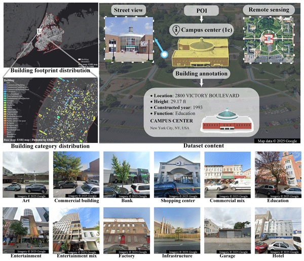
Pengxiang Su, Runfei Chen, Heng Xu, Wei Huang, Xinling Deng, Songnian Li, Wanglin Yan, Hangbin Wu, and Chun Liu
Earth Syst. Sci. Data, 18, 2609–2634, https://doi.org/10.5194/essd-18-2609-2026, https://doi.org/10.5194/essd-18-2609-2026, 2026
Short summary
Short summary
The accessibility of building function is essential for urban research. We reviewed the recent work and concluded three limitations: few open-source datasets, coarse building function categories, and poor model interpretability with inadequate multimodal feature fusion. Thus, we created BuildingSense with fine-grained categories and multimodal data, and proved that the large model can be used for improving the interpretability of results, with three directions for enhancing their performance.
Qingguo Zhang, Xiaolong Li, Huifang Feng, Jian Zhong, Yuehui Li, Michael A. Chapman, and Jonathan Li
ISPRS Ann. Photogramm. Remote Sens. Spatial Inf. Sci., X-1-W2-2025, 205–212, https://doi.org/10.5194/isprs-annals-X-1-W2-2025-205-2025, https://doi.org/10.5194/isprs-annals-X-1-W2-2025-205-2025, 2025
Jing Du, John Zelek, Michael A. Chapman, and Jonathan Li
ISPRS Ann. Photogramm. Remote Sens. Spatial Inf. Sci., X-1-W2-2025, 27–33, https://doi.org/10.5194/isprs-annals-X-1-W2-2025-27-2025, https://doi.org/10.5194/isprs-annals-X-1-W2-2025-27-2025, 2025
Gopika Rajan and Songnian Li
Int. Arch. Photogramm. Remote Sens. Spatial Inf. Sci., XLVIII-4-2024, 373–379, https://doi.org/10.5194/isprs-archives-XLVIII-4-2024-373-2024, https://doi.org/10.5194/isprs-archives-XLVIII-4-2024-373-2024, 2024
Su Yang, Jun Chen, Miaole Hou, Hongchao Fan, Songnian Li, and Yingkui Sun
ISPRS Ann. Photogramm. Remote Sens. Spatial Inf. Sci., X-4-2024, 419–425, https://doi.org/10.5194/isprs-annals-X-4-2024-419-2024, https://doi.org/10.5194/isprs-annals-X-4-2024-419-2024, 2024
Xiaoqian Hu, Yang Chen, Shishuo Xu, and Songnian Li
ISPRS Ann. Photogramm. Remote Sens. Spatial Inf. Sci., X-4-2024, 169–174, https://doi.org/10.5194/isprs-annals-X-4-2024-169-2024, https://doi.org/10.5194/isprs-annals-X-4-2024-169-2024, 2024
Deepak Satheesan, Mahdi Talib, Songnian Li, and Arnold (Xian-Xun) Yuan
Int. Arch. Photogramm. Remote Sens. Spatial Inf. Sci., XLVIII-M-4-2024, 47–53, https://doi.org/10.5194/isprs-archives-XLVIII-M-4-2024-47-2024, https://doi.org/10.5194/isprs-archives-XLVIII-M-4-2024-47-2024, 2024
S. Xu, Y. Zhao, and S. Li
Int. Arch. Photogramm. Remote Sens. Spatial Inf. Sci., XLVIII-1-W2-2023, 369–374, https://doi.org/10.5194/isprs-archives-XLVIII-1-W2-2023-369-2023, https://doi.org/10.5194/isprs-archives-XLVIII-1-W2-2023-369-2023, 2023
M. H. Ismail, A. Shaker, and S. Li
Int. Arch. Photogramm. Remote Sens. Spatial Inf. Sci., XLVIII-1-W2-2023, 7–14, https://doi.org/10.5194/isprs-archives-XLVIII-1-W2-2023-7-2023, https://doi.org/10.5194/isprs-archives-XLVIII-1-W2-2023-7-2023, 2023
S. Sattar, S. Li, and M. Chapman
Int. Arch. Photogramm. Remote Sens. Spatial Inf. Sci., XLIII-B4-2022, 281–286, https://doi.org/10.5194/isprs-archives-XLIII-B4-2022-281-2022, https://doi.org/10.5194/isprs-archives-XLIII-B4-2022-281-2022, 2022
H. He, K. Gao, W. Tan, L. Wang, S. N. Fatholahi, N. Chen, M. A. Chapman, and J. Li
Int. Arch. Photogramm. Remote Sens. Spatial Inf. Sci., XLIII-B1-2022, 31–37, https://doi.org/10.5194/isprs-archives-XLIII-B1-2022-31-2022, https://doi.org/10.5194/isprs-archives-XLIII-B1-2022-31-2022, 2022
L. Wang, W. Tan, H. Xu, H. He, N. Chen, D. Li, M. A. Chapman, and J. Li
Int. Arch. Photogramm. Remote Sens. Spatial Inf. Sci., XLIII-B1-2022, 73–78, https://doi.org/10.5194/isprs-archives-XLIII-B1-2022-73-2022, https://doi.org/10.5194/isprs-archives-XLIII-B1-2022-73-2022, 2022
Z. He, H. He, J. Li, M. A. Chapman, and H. Ding
Int. Arch. Photogramm. Remote Sens. Spatial Inf. Sci., XLIII-B1-2022, 39–44, https://doi.org/10.5194/isprs-archives-XLIII-B1-2022-39-2022, https://doi.org/10.5194/isprs-archives-XLIII-B1-2022-39-2022, 2022

The International Society for Photogrammetry and Remote Sensing is a non-governmental organization devoted to the development of international cooperation for the advancement of photogrammetry and remote sensing and their applications. The Society operates without any discrimination on grounds of race, religion, nationality, or political philosophy.
Useful Links
Useful External Links
Our Contact
c/o
Leibniz University Hannover
Institute of Photogrammetry and GeoInformation
Nienburger Str. 1
D-30167 Hannover
GERMANY
Email: isprs-sg@isprs.org