- Article
(4809 KB) - Metadata XML
- September 23, 2026
- |
- Home
- |
- Sitemap
- |
- The ISPRS Foundation
- |
- 𝕏
The International Archives of the Photogrammetry, Remote Sensing and Spatial Information Sciences





Articles | Volume XLIX-B5-2026
https://doi.org/10.5194/isprs-archives-XLIX-B5-2026-79-2026
© Author(s) 2026. This work is distributed under
the Creative Commons Attribution 4.0 License.
the Creative Commons Attribution 4.0 License.
https://doi.org/10.5194/isprs-archives-XLIX-B5-2026-79-2026
© Author(s) 2026. This work is distributed under
the Creative Commons Attribution 4.0 License.
the Creative Commons Attribution 4.0 License.

04 Aug 2026
| 04 Aug 2026
DINAMIS: The French National online Facility dedicated to the Pooling and Sharing of very high spatial Resolution Satellite Imagery for Non-commercial Applications
Jean-Francois Faure
IRD, French national Research Institute for Sustainable Development, France, IR Data Terra and UMR Espace-dev, IRD, University of Montpellier, University of French Guiana, University of La Réunion, Montpellier, France
Anna Cristofol
IGN, French National Institute of Geographic and Forest Information, France
Etienne Berthier
CNRS, French National Center for Scientific Research, France
Nadia Landachoco
CNES, French National Center for Space Studies, France
Jean-Philippe Caminade
IRD, French national Research Institute for Sustainable Development, France, UMR Espace-dev, IRD, University of Montpellier, University of French Guiana, University of La Réunion, Montpellier, France
Jean-Paul Sempère
IGN, French National Institute of Geographic and Forest Information, France
Stéphane Dupuy
CIRAD, French Agricultural Research Center for Development UMR TETIS, F-34398 Montpellier, France, UMR TETIS, University of Montpellier, AgroParisTech, INRAE, CIRAD, CNRS, France
Pierre Maurel
INRAE, French National Research Institute for Agriculture, Food and Environment, UMR TETIS, University of Montpellier, AgroParisTech, INRAE, CIRAD, CNRS, France
Related authors
Laurent Polidori, Alessandra Gomes, and Jean-Francois Faure
Int. Arch. Photogramm. Remote Sens. Spatial Inf. Sci., XLIX-B3-2026, 1–1, https://doi.org/10.5194/isprs-archives-XLIX-B3-2026-1-2026, https://doi.org/10.5194/isprs-archives-XLIX-B3-2026-1-2026, 2026
Laurent Polidori, Alessandra Gomes, and Jean-Francois Faure
ISPRS Ann. Photogramm. Remote Sens. Spatial Inf. Sci., XI-3-2026, 995–995, https://doi.org/10.5194/isprs-annals-XI-3-2026-995-2026, https://doi.org/10.5194/isprs-annals-XI-3-2026-995-2026, 2026
Elodie Blanchard, Thibault Catry, Quentin Marsal, Eric Delaître, Christophe Proisy, and Jean-François Faure
Int. Arch. Photogramm. Remote Sens. Spatial Inf. Sci., XLVIII-3-2024, 35–41, https://doi.org/10.5194/isprs-archives-XLVIII-3-2024-35-2024, https://doi.org/10.5194/isprs-archives-XLVIII-3-2024-35-2024, 2024
Laurent Polidori, Alessandra Gomes, and Jean-Francois Faure
Int. Arch. Photogramm. Remote Sens. Spatial Inf. Sci., XLIX-B3-2026, 1–1, https://doi.org/10.5194/isprs-archives-XLIX-B3-2026-1-2026, https://doi.org/10.5194/isprs-archives-XLIX-B3-2026-1-2026, 2026
Laurent Polidori, Alessandra Gomes, and Jean-Francois Faure
ISPRS Ann. Photogramm. Remote Sens. Spatial Inf. Sci., XI-3-2026, 995–995, https://doi.org/10.5194/isprs-annals-XI-3-2026-995-2026, https://doi.org/10.5194/isprs-annals-XI-3-2026-995-2026, 2026
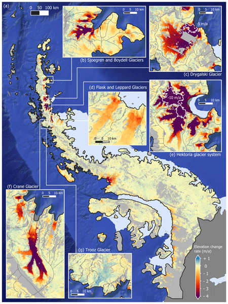
Maud Bernat, Etienne Berthier, Amaury Dehecq, Romain Hugonnet, Joaquin M. C. Belart, Naomi Ochwat, Peter Kuipers Munneke, Elizabeth Case, Ted Scambos, Louis-Marie Gauer, and David Youssefi
The Cryosphere, 20, 3025–3049, https://doi.org/10.5194/tc-20-3025-2026, https://doi.org/10.5194/tc-20-3025-2026, 2026
Short summary
Short summary
The Antarctic Peninsula is a mountainous region containing an ice sheet and peripheral glaciers. Differences remain between the methods used to estimate its mass changes. We use thousands of digital elevation models derived from high resolution stereoscopic images to calculate a new estimate of mass changes. We find that between 2007 and 2021, the ice sheet lost -28±6Gt/a and its peripheral glaciers -14±3Gt/a. We highlight the importance of resolving fine-scale changes in complex coastal areas.
Simon Filhol, Clément Misset, Noélie Bontemps, Diego Cusicanqui, Emmanuel Paquet, Marie Dumont, Olivier Gagliardini, Pascal Lacroix, Simon Gascoin, Guillaume Thirel, Julien Brondex, Pascal Hagenmuller, Eric Larose, Philipp Schoeneich, Denis Roy, Emmanuel Thibert, Nicolas Eckert, Félix de Montety, Robin Mainieri, Alexandre Hauet, Frédéric Gottardi, Johan Berthet, Alexandre Baratier, Frédéric Liébault, Małgorzata Chmiel, Guillaume Piton, Guillaume Chambon, Guillaume James, Philippe Frey, Philip Deline, Laurent Astrade, Christian Vincent, Dominique Laigle, Alain Recking, Fatima Karbou, Adrien Mauss, Mylène Bonnefoy-Demongeot, Firmin Fontaine, Mickael Langlais, Etienne Berthier, and Antoine Blanc
EGUsphere, https://doi.org/10.5194/egusphere-2026-971, https://doi.org/10.5194/egusphere-2026-971, 2026
Short summary
Short summary
On June 21 2024, the village of La Bérarde, in the French Alps, was devastated by a flood destroying centuries old buildings. This study is an interdisciplinary work to decipher the causes and chronology of the event. The flood started with decadal rain falling on a thick snowpack. A lake observed on top of a glacier few days prior, had drained post event. With climate change, should we expect more similar compound events for alpine communities?
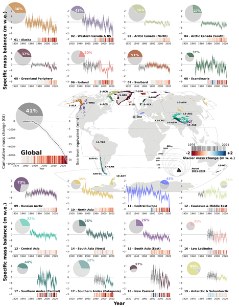
Inés Dussaillant, Romain Hugonnet, Matthias Huss, Etienne Berthier, Jacqueline Bannwart, Frank Paul, and Michael Zemp
Earth Syst. Sci. Data, 17, 1977–2006, https://doi.org/10.5194/essd-17-1977-2025, https://doi.org/10.5194/essd-17-1977-2025, 2025
Short summary
Short summary
Our research observes glacier mass changes worldwide from 1976 to 2024, revealing an alarming increase in melt, especially in the last decade and the record year of 2023. By combining field and satellite observations, we provide annual mass changes for all glaciers in the world, showing significant contributions to global sea level rise. This work underscores the need for ongoing local monitoring and global climate action to mitigate the effects of glacier loss and its broader environmental impacts.
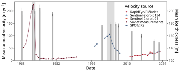
Enrico Mattea, Etienne Berthier, Amaury Dehecq, Tobias Bolch, Atanu Bhattacharya, Sajid Ghuffar, Martina Barandun, and Martin Hoelzle
The Cryosphere, 19, 219–247, https://doi.org/10.5194/tc-19-219-2025, https://doi.org/10.5194/tc-19-219-2025, 2025
Short summary
Short summary
We reconstruct the evolution of terminus position, ice thickness, and surface flow velocity of the reference Abramov glacier (Kyrgyzstan) from 1968 to present. We describe a front pulsation in the early 2000s and the multi-annual present-day buildup of a new pulsation. Such dynamic instabilities can challenge the representativity of Abramov as a reference glacier. For our work we used satellite‑based optical remote sensing from multiple platforms, including recently declassified archives.
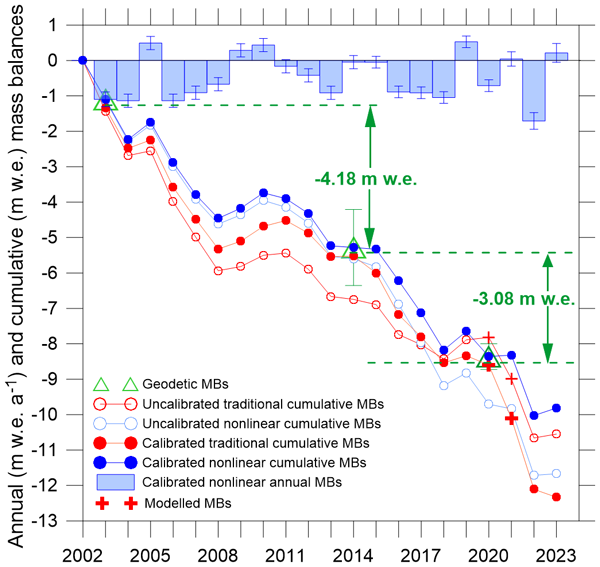
Mohd Farooq Azam, Christian Vincent, Smriti Srivastava, Etienne Berthier, Patrick Wagnon, Himanshu Kaushik, Md. Arif Hussain, Manoj Kumar Munda, Arindan Mandal, and Alagappan Ramanathan
The Cryosphere, 18, 5653–5672, https://doi.org/10.5194/tc-18-5653-2024, https://doi.org/10.5194/tc-18-5653-2024, 2024
Short summary
Short summary
Mass balance series on Chhota Shigri Glacier has been reanalysed by combining the traditional mass balance reanalysis framework and a nonlinear model. The nonlinear model is preferred over traditional glaciological methods to compute the mass balances, as the former can capture the spatiotemporal variability in point mass balances from a heterogeneous in situ point mass balance network. The nonlinear model outperforms the traditional method and agrees better with the geodetic estimates.
Etienne Berthier, Jérôme Lebreton, Delphine Fontannaz, Steven Hosford, Joaquín Muñoz-Cobo Belart, Fanny Brun, Liss M. Andreassen, Brian Menounos, and Charlotte Blondel
The Cryosphere, 18, 5551–5571, https://doi.org/10.5194/tc-18-5551-2024, https://doi.org/10.5194/tc-18-5551-2024, 2024
Short summary
Short summary
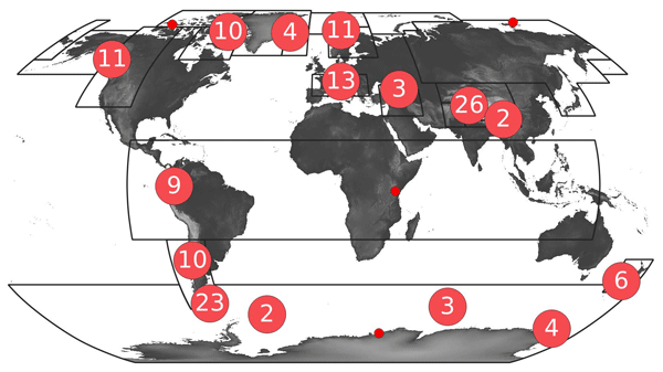
Repeat elevation measurements are crucial for monitoring glacier health and to understand how glaciers affect river flows and sea level. Until recently, high-resolution elevation data were mostly available for polar regions and High Mountain Asia. Our project, the Pléiades Glacier Observatory, now provides high-resolution topographies of 140 glacier sites worldwide. This is a novel and open dataset to monitor the impact of climate change on glaciers at high resolution and accuracy.
Elodie Blanchard, Thibault Catry, Quentin Marsal, Eric Delaître, Christophe Proisy, and Jean-François Faure
Int. Arch. Photogramm. Remote Sens. Spatial Inf. Sci., XLVIII-3-2024, 35–41, https://doi.org/10.5194/isprs-archives-XLVIII-3-2024-35-2024, https://doi.org/10.5194/isprs-archives-XLVIII-3-2024-35-2024, 2024
Livia Piermattei, Michael Zemp, Christian Sommer, Fanny Brun, Matthias H. Braun, Liss M. Andreassen, Joaquín M. C. Belart, Etienne Berthier, Atanu Bhattacharya, Laura Boehm Vock, Tobias Bolch, Amaury Dehecq, Inés Dussaillant, Daniel Falaschi, Caitlyn Florentine, Dana Floricioiu, Christian Ginzler, Gregoire Guillet, Romain Hugonnet, Matthias Huss, Andreas Kääb, Owen King, Christoph Klug, Friedrich Knuth, Lukas Krieger, Jeff La Frenierre, Robert McNabb, Christopher McNeil, Rainer Prinz, Louis Sass, Thorsten Seehaus, David Shean, Désirée Treichler, Anja Wendt, and Ruitang Yang
The Cryosphere, 18, 3195–3230, https://doi.org/10.5194/tc-18-3195-2024, https://doi.org/10.5194/tc-18-3195-2024, 2024
Short summary
Short summary
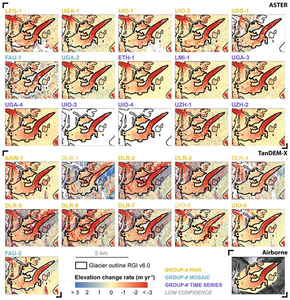
Satellites have made it possible to observe glacier elevation changes from all around the world. In the present study, we compared the results produced from two different types of satellite data between different research groups and against validation measurements from aeroplanes. We found a large spread between individual results but showed that the group ensemble can be used to reliably estimate glacier elevation changes and related errors from satellite data.
Fanny Brun, Owen King, Marion Réveillet, Charles Amory, Anton Planchot, Etienne Berthier, Amaury Dehecq, Tobias Bolch, Kévin Fourteau, Julien Brondex, Marie Dumont, Christoph Mayer, Silvan Leinss, Romain Hugonnet, and Patrick Wagnon
The Cryosphere, 17, 3251–3268, https://doi.org/10.5194/tc-17-3251-2023, https://doi.org/10.5194/tc-17-3251-2023, 2023
Short summary
Short summary
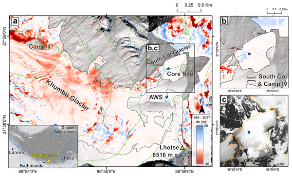
The South Col Glacier is a small body of ice and snow located on the southern ridge of Mt. Everest. A recent study proposed that South Col Glacier is rapidly losing mass. In this study, we examined the glacier thickness change for the period 1984–2017 and found no thickness change. To reconcile these results, we investigate wind erosion and surface energy and mass balance and find that melt is unlikely a dominant process, contrary to previous findings.
Maximillian Van Wyk de Vries, Shashank Bhushan, Mylène Jacquemart, César Deschamps-Berger, Etienne Berthier, Simon Gascoin, David E. Shean, Dan H. Shugar, and Andreas Kääb
Nat. Hazards Earth Syst. Sci., 22, 3309–3327, https://doi.org/10.5194/nhess-22-3309-2022, https://doi.org/10.5194/nhess-22-3309-2022, 2022
Short summary
Short summary
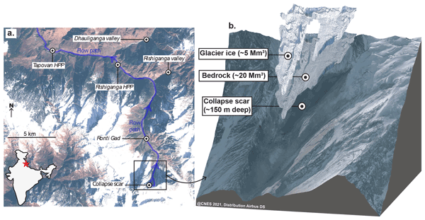
On 7 February 2021, a large rock–ice avalanche occurred in Chamoli, Indian Himalaya. The resulting debris flow swept down the nearby valley, leaving over 200 people dead or missing. We use a range of satellite datasets to investigate how the collapse area changed prior to collapse. We show that signs of instability were visible as early 5 years prior to collapse. However, it would likely not have been possible to predict the timing of the event from current satellite datasets.
Audrey Jolivot, Valentine Lebourgeois, Louise Leroux, Mael Ameline, Valérie Andriamanga, Beatriz Bellón, Mathieu Castets, Arthur Crespin-Boucaud, Pierre Defourny, Santiana Diaz, Mohamadou Dieye, Stéphane Dupuy, Rodrigo Ferraz, Raffaele Gaetano, Marie Gely, Camille Jahel, Bertin Kabore, Camille Lelong, Guerric le Maire, Danny Lo Seen, Martha Muthoni, Babacar Ndao, Terry Newby, Cecília Lira Melo de Oliveira Santos, Eloise Rasoamalala, Margareth Simoes, Ibrahima Thiaw, Alice Timmermans, Annelise Tran, and Agnès Bégué
Earth Syst. Sci. Data, 13, 5951–5967, https://doi.org/10.5194/essd-13-5951-2021, https://doi.org/10.5194/essd-13-5951-2021, 2021
Short summary
Short summary
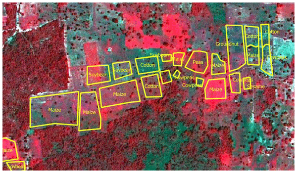
This paper presents nine standardized crop type reference datasets collected between 2013 and 2020 in seven tropical countries. It aims at participating in the difficult exercise of mapping agricultural land use through satellite image classification in those complex areas where few ground truth or census data are available. These quality-controlled datasets were collected in the framework of the international JECAM initiative and contain 27 074 polygons documented by detailed keywords.

The International Society for Photogrammetry and Remote Sensing is a non-governmental organization devoted to the development of international cooperation for the advancement of photogrammetry and remote sensing and their applications. The Society operates without any discrimination on grounds of race, religion, nationality, or political philosophy.
Useful Links
Useful External Links
Our Contact
c/o
Leibniz University Hannover
Institute of Photogrammetry and GeoInformation
Nienburger Str. 1
D-30167 Hannover
GERMANY
Email: isprs-sg@isprs.org