- Article
(4415 KB) - Metadata XML
- October 17, 2026
- |
- Home
- |
- Sitemap
- |
- The ISPRS Foundation
- |
- 𝕏
The International Archives of the Photogrammetry, Remote Sensing and Spatial Information Sciences





Articles | Volume XLVIII-G-2025
https://doi.org/10.5194/isprs-archives-XLVIII-G-2025-1023-2025
© Author(s) 2025. This work is distributed under
the Creative Commons Attribution 4.0 License.
the Creative Commons Attribution 4.0 License.
https://doi.org/10.5194/isprs-archives-XLVIII-G-2025-1023-2025
© Author(s) 2025. This work is distributed under
the Creative Commons Attribution 4.0 License.
the Creative Commons Attribution 4.0 License.

30 Jul 2025
| 30 Jul 2025
LuTan-1 Satellite-Based Geological Disaster Detection in Lingbao City, Western Henan of China
Jing Lu
Land Satellite Remote Sensing Application Center, MNR, Beijing 100048, China
Xinming Tang
Land Satellite Remote Sensing Application Center, MNR, Beijing 100048, China
Lei Wei
Henan Geological Bureau Mineral Resources Exploration Center, Henan 450016, China
Lingfei Guo
Henan Geological Bureau Mineral Resources Exploration Center, Henan 450016, China
Land Satellite Remote Sensing Application Center, MNR, Beijing 100048, China
Xiang Zhang
Land Satellite Remote Sensing Application Center, MNR, Beijing 100048, China
Xuefei Zhang
Land Satellite Remote Sensing Application Center, MNR, Beijing 100048, China
Related authors
Tao Li, Xinming Tang, Xiang Zhang, Jing Lu, Xin Tian, and Xuefei Zhang
ISPRS Ann. Photogramm. Remote Sens. Spatial Inf. Sci., XI-1-2026, 119–124, https://doi.org/10.5194/isprs-annals-XI-1-2026-119-2026, https://doi.org/10.5194/isprs-annals-XI-1-2026-119-2026, 2026
Jing Lu, Xinming Tang, Tao Li, Xiang Zhang, Xuefei Zhang, Tan Li, Xiaofeng Qiu, and Yao Lu
ISPRS Ann. Photogramm. Remote Sens. Spatial Inf. Sci., XI-1-2026, 125–130, https://doi.org/10.5194/isprs-annals-XI-1-2026-125-2026, https://doi.org/10.5194/isprs-annals-XI-1-2026-125-2026, 2026
Xinming Tang, Yao Lu, Tao Li, Xiaoqing Zhou, Jing Lu, Xiang Zhang, Xuefei Zhang, Xiaofeng Qiu, and Jiyi Chen
ISPRS Ann. Photogramm. Remote Sens. Spatial Inf. Sci., XI-1-2026, 131–136, https://doi.org/10.5194/isprs-annals-XI-1-2026-131-2026, https://doi.org/10.5194/isprs-annals-XI-1-2026-131-2026, 2026
Xiang Zhang, Xinming Tang, Tao Li, Xiaoqing Zhou, Haifeng Hu, Xuefei Zhang, and Jing Lu
Int. Arch. Photogramm. Remote Sens. Spatial Inf. Sci., XLVIII-1-2024, 867–873, https://doi.org/10.5194/isprs-archives-XLVIII-1-2024-867-2024, https://doi.org/10.5194/isprs-archives-XLVIII-1-2024-867-2024, 2024
Xuefei Zhang, Tao Li, Xiang Zhang, Xiaoqing Zhou, Jing Lu, and Xueguang Zhang
Int. Arch. Photogramm. Remote Sens. Spatial Inf. Sci., XLVIII-1-2024, 875–880, https://doi.org/10.5194/isprs-archives-XLVIII-1-2024-875-2024, https://doi.org/10.5194/isprs-archives-XLVIII-1-2024-875-2024, 2024
Jing Lu, Xinming Tang, Tao Li, Xiang Zhang, Xuefei Zhang, Tan Li, and Xiaofeng Qiu
Int. Arch. Photogramm. Remote Sens. Spatial Inf. Sci., XLVIII-1-2024, 457–462, https://doi.org/10.5194/isprs-archives-XLVIII-1-2024-457-2024, https://doi.org/10.5194/isprs-archives-XLVIII-1-2024-457-2024, 2024
T. Li, X. Tang, X. Gao, X. Zhang, X. Zhang, J. Lu, T. Chen, X. Qiao, J. Han, and Z. Li
Int. Arch. Photogramm. Remote Sens. Spatial Inf. Sci., XLVIII-1-W2-2023, 1251–1256, https://doi.org/10.5194/isprs-archives-XLVIII-1-W2-2023-1251-2023, https://doi.org/10.5194/isprs-archives-XLVIII-1-W2-2023-1251-2023, 2023
Tao Li, Xinming Tang, Xiang Zhang, Jing Lu, Xin Tian, and Xuefei Zhang
ISPRS Ann. Photogramm. Remote Sens. Spatial Inf. Sci., XI-1-2026, 119–124, https://doi.org/10.5194/isprs-annals-XI-1-2026-119-2026, https://doi.org/10.5194/isprs-annals-XI-1-2026-119-2026, 2026
Jing Lu, Xinming Tang, Tao Li, Xiang Zhang, Xuefei Zhang, Tan Li, Xiaofeng Qiu, and Yao Lu
ISPRS Ann. Photogramm. Remote Sens. Spatial Inf. Sci., XI-1-2026, 125–130, https://doi.org/10.5194/isprs-annals-XI-1-2026-125-2026, https://doi.org/10.5194/isprs-annals-XI-1-2026-125-2026, 2026
Xinming Tang, Yao Lu, Tao Li, Xiaoqing Zhou, Jing Lu, Xiang Zhang, Xuefei Zhang, Xiaofeng Qiu, and Jiyi Chen
ISPRS Ann. Photogramm. Remote Sens. Spatial Inf. Sci., XI-1-2026, 131–136, https://doi.org/10.5194/isprs-annals-XI-1-2026-131-2026, https://doi.org/10.5194/isprs-annals-XI-1-2026-131-2026, 2026
Xiang Zhang, Xinming Tang, Hui Zhao, and Tao Li
ISPRS Ann. Photogramm. Remote Sens. Spatial Inf. Sci., XI-1-2026, 137–142, https://doi.org/10.5194/isprs-annals-XI-1-2026-137-2026, https://doi.org/10.5194/isprs-annals-XI-1-2026-137-2026, 2026
Jinhao Xu, Min Feng, Yijie Sui, Yanan Su, Xuefei Zhang, Qinglin Wu, Zhimin Hu, and Ruilin Wang
The Cryosphere, 20, 2851–2870, https://doi.org/10.5194/tc-20-2851-2026, https://doi.org/10.5194/tc-20-2851-2026, 2026
Short summary
Short summary
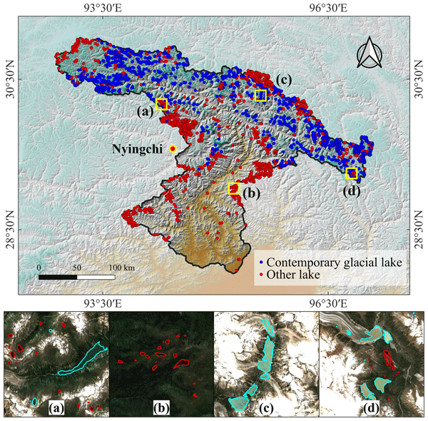
Lakes in alpine periglacial environments are expanding rapidly under climate warming, but their detection and classification remain difficult because of complex terrain and spectral interference. We developed a vision-transformer-based framework to delineate lake boundaries and distinguish contemporary glacial lakes from other lakes. Applied to the southeastern Tibetan Plateau, it identified 3,266 lakes, including many as small as 0.0001 km².
Xiang Zhang, Hui Zhao, Xinming Tang, Tao Li, Xiaoqing Zhou, and Xuefei Zhang
Int. Arch. Photogramm. Remote Sens. Spatial Inf. Sci., XLVIII-G-2025, 1715–1720, https://doi.org/10.5194/isprs-archives-XLVIII-G-2025-1715-2025, https://doi.org/10.5194/isprs-archives-XLVIII-G-2025-1715-2025, 2025
Peimingyan Tian, Xinming Tang, Xiaoyong Zhu, Dian Qu, Jianhang Ding, and Yaobin Li
Int. Arch. Photogramm. Remote Sens. Spatial Inf. Sci., XLVIII-3-2024, 547–552, https://doi.org/10.5194/isprs-archives-XLVIII-3-2024-547-2024, https://doi.org/10.5194/isprs-archives-XLVIII-3-2024-547-2024, 2024
Fanghong Ye, Sida Ouyang, Xinming Tang, Amos T. Kabo-Bah, and Chen Lu
Int. Arch. Photogramm. Remote Sens. Spatial Inf. Sci., XLVIII-3-2024, 595–600, https://doi.org/10.5194/isprs-archives-XLVIII-3-2024-595-2024, https://doi.org/10.5194/isprs-archives-XLVIII-3-2024-595-2024, 2024
Xiang Zhang, Xinming Tang, Tao Li, Xiaoqing Zhou, Haifeng Hu, Xuefei Zhang, and Jing Lu
Int. Arch. Photogramm. Remote Sens. Spatial Inf. Sci., XLVIII-1-2024, 867–873, https://doi.org/10.5194/isprs-archives-XLVIII-1-2024-867-2024, https://doi.org/10.5194/isprs-archives-XLVIII-1-2024-867-2024, 2024
Xuefei Zhang, Tao Li, Xiang Zhang, Xiaoqing Zhou, Jing Lu, and Xueguang Zhang
Int. Arch. Photogramm. Remote Sens. Spatial Inf. Sci., XLVIII-1-2024, 875–880, https://doi.org/10.5194/isprs-archives-XLVIII-1-2024-875-2024, https://doi.org/10.5194/isprs-archives-XLVIII-1-2024-875-2024, 2024
Xinming Tang, Antonio Maria Garcia Tommaselli, Tao Zhang, and Junfeng Xie
Int. Arch. Photogramm. Remote Sens. Spatial Inf. Sci., XLVIII-1-2024, 935–935, https://doi.org/10.5194/isprs-archives-XLVIII-1-2024-935-2024, https://doi.org/10.5194/isprs-archives-XLVIII-1-2024-935-2024, 2024
Yanyang Liu, Mingliang Tao, Jieshuang Li, Tao Li, and Junli Chen
Int. Arch. Photogramm. Remote Sens. Spatial Inf. Sci., XLVIII-1-2024, 425–430, https://doi.org/10.5194/isprs-archives-XLVIII-1-2024-425-2024, https://doi.org/10.5194/isprs-archives-XLVIII-1-2024-425-2024, 2024
Jing Lu, Xinming Tang, Tao Li, Xiang Zhang, Xuefei Zhang, Tan Li, and Xiaofeng Qiu
Int. Arch. Photogramm. Remote Sens. Spatial Inf. Sci., XLVIII-1-2024, 457–462, https://doi.org/10.5194/isprs-archives-XLVIII-1-2024-457-2024, https://doi.org/10.5194/isprs-archives-XLVIII-1-2024-457-2024, 2024
Xinming Tang, Antonio Maria Garcia Tommaselli, Tao Zhang, and Junfeng Xie
ISPRS Ann. Photogramm. Remote Sens. Spatial Inf. Sci., X-1-2024, 321–321, https://doi.org/10.5194/isprs-annals-X-1-2024-321-2024, https://doi.org/10.5194/isprs-annals-X-1-2024-321-2024, 2024
T. Li, X. Tang, X. Gao, X. Zhang, X. Zhang, J. Lu, T. Chen, X. Qiao, J. Han, and Z. Li
Int. Arch. Photogramm. Remote Sens. Spatial Inf. Sci., XLVIII-1-W2-2023, 1251–1256, https://doi.org/10.5194/isprs-archives-XLVIII-1-W2-2023-1251-2023, https://doi.org/10.5194/isprs-archives-XLVIII-1-W2-2023-1251-2023, 2023
X. Gao, L. Wang, T. Li, and J. Xie
ISPRS Ann. Photogramm. Remote Sens. Spatial Inf. Sci., X-1-W1-2023, 821–826, https://doi.org/10.5194/isprs-annals-X-1-W1-2023-821-2023, https://doi.org/10.5194/isprs-annals-X-1-W1-2023-821-2023, 2023

The International Society for Photogrammetry and Remote Sensing is a non-governmental organization devoted to the development of international cooperation for the advancement of photogrammetry and remote sensing and their applications. The Society operates without any discrimination on grounds of race, religion, nationality, or political philosophy.
Useful Links
Useful External Links
Our Contact
c/o
Leibniz University Hannover
Institute of Photogrammetry and GeoInformation
Nienburger Str. 1
D-30167 Hannover
GERMANY
Email: isprs-sg@isprs.org