- Article
(2068 KB) - Metadata XML
- October 23, 2026
- |
- Home
- |
- Sitemap
- |
- The ISPRS Foundation
- |
- 𝕏
The International Archives of the Photogrammetry, Remote Sensing and Spatial Information Sciences





Articles | Volume XLVIII-M-6-2025
https://doi.org/10.5194/isprs-archives-XLVIII-M-6-2025-393-2025
© Author(s) 2025. This work is distributed under
the Creative Commons Attribution 4.0 License.
the Creative Commons Attribution 4.0 License.
https://doi.org/10.5194/isprs-archives-XLVIII-M-6-2025-393-2025
© Author(s) 2025. This work is distributed under
the Creative Commons Attribution 4.0 License.
the Creative Commons Attribution 4.0 License.

23 May 2025
| 23 May 2025
Vertical Crustal Movement along the Coast of South Africa
Franck Eitel Kemgang Ghomsi
Centre for Earth Observation Science, University of Manitoba, Winnipeg, MB, Canada
Nansen-Tutu Center for Marine Environmental Research, Department of Oceanography, University of Cape Town, South Africa
Geodesy Research Laboratory, National Institute of Cartography, P.O. Box 157, Yaoundé, Cameroon
Muharrem Hilmi Erkoç
Department of Geomatic Engineering, Yildiz Technical University, 34220, Istanbul, Türkiye
Roshin P. Raj
Nansen Environmental and Remote Sensing Center and Bjerknes Center for Climate Research, Bergen, Norway
Atinç Pirti
Department of Geomatic Engineering, Yildiz Technical University, 34220, Istanbul, Türkiye
Antonio Bonaduce
Nansen Environmental and Remote Sensing Center and Bjerknes Center for Climate Research, Bergen, Norway
Babatunde J. Abiodun
Nansen-Tutu Center for Marine Environmental Research, Department of Oceanography, University of Cape Town, South Africa
Climate System Analysis Group, Department of Environmental and Geographical Science, University of Cape Town, Cape Town, South Africa
Julienne Stroeve
Centre for Earth Observation Science, University of Manitoba, Winnipeg, MB, Canada
Department of Earth Sciences, University College London, London, UK
National Snow and Ice Data Center, Cooperative Institute for Research in Environmental Science, University of Colorado Boulder, Boulder, CO, USA
Related authors
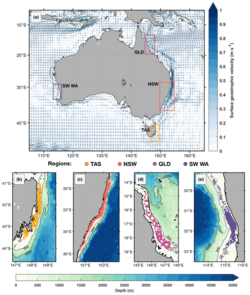
Daneeja Mawren, Julia Araujo, Romain Le Gendre, Jessica A. Benthuysen, Franck Eitel Kemgang Ghomsi, Jayanthi S. Saranya, and Amandine Schaeffer
Ocean Sci., 22, 1793–1817, https://doi.org/10.5194/os-22-1793-2026, https://doi.org/10.5194/os-22-1793-2026, 2026
Short summary
Short summary
Using 16 years of ocean glider data, we show that marine heatwaves are characterised by shallow mixed layers and alter subsurface biogeochemistry across Australia’s continental shelf. Surface chlorophyll generally declined, but strong stratification and event severity promoted deeper, intensified chlorophyll maxima, highlighting region-specific ecological responses to heatwaves.
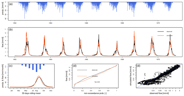
Rodric Mérimé Nonki, Ernest Amoussou, Raphael Muamba Tshimanga, Djan'na Koubodana Houteta, Domiho Japhet Kodja, Franck Eitel Kemgang Ghomsi, and André Lenouo
Proc. IAHS, 385, 319–326, https://doi.org/10.5194/piahs-385-319-2024, https://doi.org/10.5194/piahs-385-319-2024, 2024
Short summary
Short summary
This research aims to evaluate the feasibility of using multiple rainfall-runoff hydrologic models Génie Rural à 4, 5, 6 paramètres Journalier (GR4J, GR5J, and GR6J) in the Upper Benue River (UBR) in Northern Cameroon. By using the Michel's calibration algorithm, we found that the composite criterion is the most sustainable objective function for model optimization. An honest evaluation empirically proves that the GR6J model performs better than the other two models follow by GR5J.
Bjorn Backeberg, Jemma Johnson, Natalia Aleksandrova, Cornelis Slobbe, Fabio Mangini, Marcello Passaro, Sanne Muis, Pavel Ditmar, Antonio Bonaduce, Gundula Winter, and Michael Hart-Davis
EGUsphere, https://doi.org/10.5194/egusphere-2026-3916, https://doi.org/10.5194/egusphere-2026-3916, 2026
This preprint is open for discussion and under review for Natural Hazards and Earth System Sciences (NHESS).
Short summary
Short summary
Coastal cities face growing flood risk from rising seas and storms. Scientists estimate dangerous water levels using satellite measurements of sea level and computer models of ocean behaviour, but the two are often combined inconsistently. We reviewed this research and found the real challenge is not merging the data, but making sure both methods measure the same thing, the same way. Solving this could lead to more reliable, consistent flood-risk estimates for coastal communities worldwide.
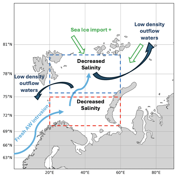
Roshin P. Raj, Vidar S. Lien, Sourav Chatterjee, Saradhy Surendran, Antonio Bonaduce, and Laurent Bertino
State Planet, 7-osr10, 6, https://doi.org/10.5194/sp-7-osr10-6-2026, https://doi.org/10.5194/sp-7-osr10-6-2026, 2026
Short summary
Short summary
Dense water formed and exiting from the Barents Sea constitutes an important part of the global ocean circulation. Considering the significant impact of salinity changes in dense water formation, we investigate the salinity changes in the Barents Sea during the past 3 decades. Our results highlight the recent freshening and its drivers in the northern and southern Barents Sea and show its impact on the density of the waters exiting the Barents Sea.
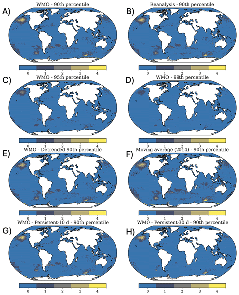
Alex Hayward, Nishka Dasgupta, Ronan McAdam, Mark R. Payne, Roshin P. Raj, Giulia Bonino, Sourav Chatterjee, Vincent Combes, Dimitra Denaxa, Francesco De Rovere, Pia Englyst, Veera Haapaniemi, Paul Hargous, Jacob Høyer, K. Ajith Joseph, Beatriz Lopes, Ana Oliveira, João Paixão, Fabiola Silva, Saradhy Surendran, Artemis Zegna-Rata, and Steffen M. Olsen
Earth Syst. Sci. Data, 18, 7181–7197, https://doi.org/10.5194/essd-18-7181-2026, https://doi.org/10.5194/essd-18-7181-2026, 2026
Short summary
Short summary
We present a global marine heatwave and cold spell dataset (1982–2024) based on satellite sea surface temperature. The dataset applies multiple definitions in parallel, varying baselines, thresholds, detrending, and event durations. It enables consistent comparisons of marine heatwave characterisation across methods and supports climate monitoring, and ecological impact studies.
Michael G. Hart-Davis, Blanca E. Torunski, Antonio Bonaduce, Torbjørn Taskjelle, and Johnny A. Johannessen
EGUsphere, https://doi.org/10.5194/egusphere-2026-5493, https://doi.org/10.5194/egusphere-2026-5493, 2026
This preprint is open for discussion and under review for Ocean Science (OS).
Short summary
Short summary
Observations are of fundamental importance for researching ocean variability. For tidal research, tide gauges have enabled a deep understanding of the physical mechanisms driving tides, as well as how they vary across the coastal oceans. In this manuscript, we assess the tides of Norway from a dense network of tide gauges that have been deployed by the Norwegian Mapping Authority. We dive into tidal components, tidal datums, and validation of global ocean tide models.
Gaëlle Veyssière, Julienne Stroeve, Ran Tao, and Bruce C. Forbes
EGUsphere, https://doi.org/10.5194/egusphere-2026-5279, https://doi.org/10.5194/egusphere-2026-5279, 2026
This preprint is open for discussion and under review for The Cryosphere (TC).
Short summary
Short summary
We examined how winter rain falling on snow may change across northwestern Eurasia as the climate warms. Using projections from nine climate models, we found more winter precipitation and a larger portion falling as rain. Rain-on-snow events become less concentrated in spring and occur over more of the winter, while some southern areas lose spring events as snow cover becomes less persistent. These changes could affect snow conditions, reindeer herding, ecosystems, transport and infrastructure.
Alejandro Blazquez, Benoit Meyssignac, Robin Fraudeau, Michael Ablain, Jonathan Bamber, Antonio Bonaduce, Marie Bouih, Anny Cazenave, Thorben Döhne, Ines Dussaillant, Ramiro Ferrari, Martin Horwath, Nicolas Kolodziejczyk, Hugo Lecomte, Stephanie Leroux, William Llovel, Daniele Melini, Erwan Oulhen, Thierry Penduff, Roshin P. Raj, Giorgio Spada, Marius Schlaak, Papasarafianou Stamatia, Andrea Storto, Chunxue Yang, and Sarah Connors
Earth Syst. Sci. Data Discuss., https://doi.org/10.5194/essd-2026-627, https://doi.org/10.5194/essd-2026-627, 2026
Preprint under review for ESSD
Short summary
Short summary
Closing the sea‑level budget on annual and longer time scales is a cornerstone of physical oceanography because sea‑level rise is one of the best indicators of climate change, and a closed budget shows we have identified and quantified all major drivers. We examined it from 1993 to 2022, finding an accelerated rise that matched ice melt and warm water until 2015. Afterwards an unexplained gap appears. Better deep‑ocean observations and refined gravity processing are needed to close the budget.
Anton Komarov and Julienne Stroeve
EGUsphere, https://doi.org/10.5194/egusphere-2026-3873, https://doi.org/10.5194/egusphere-2026-3873, 2026
Preprint archived
Short summary
Short summary
Warming climate and changing precipitation regimes in Arctic and boreal regions cause frequent rain-on-snow events when liquid water precipitate on the snow surface leading to water infiltration, heterogeneous flow, and the development of refrozen percolation features within the snowpack. These processes change the physical properties of the snow and may lead to liquid-water runoff. In this paper, we investigate how local factors affect these processes in a taiga environment.
Julienne Stroeve, Rosemary Willatt, Madeleine Downie, Monojit Saha, Carmen Nab, Alicia Fallows, Clement Soriot, Robbie Mallett, Anton Komarov, Vishnu Nandan, Thomas Newman, Jennifer Lukovich, and John Yackel
The Cryosphere, 20, 4367–4399, https://doi.org/10.5194/tc-20-4367-2026, https://doi.org/10.5194/tc-20-4367-2026, 2026
Short summary
Short summary
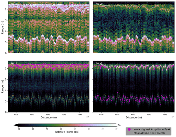
We evaluate polarimetry for snow depth retrieval on Arctic winter transport routes. Over landfast ice and tundra, traditional dual-frequency (Ku/Ka) methods often fail. We demonstrate that cross-polarization (VH) provides a more reliable marker for snow/ice and snow/ground interfaces. For lakes, we successfully resolve air, snow, and ice interfaces to retrieve snow and ice thickness simultaneously. These results establish a baseline for future polarimetric satellite missions.
Daneeja Mawren, Julia Araujo, Romain Le Gendre, Jessica A. Benthuysen, Franck Eitel Kemgang Ghomsi, Jayanthi S. Saranya, and Amandine Schaeffer
Ocean Sci., 22, 1793–1817, https://doi.org/10.5194/os-22-1793-2026, https://doi.org/10.5194/os-22-1793-2026, 2026
Short summary
Short summary
Using 16 years of ocean glider data, we show that marine heatwaves are characterised by shallow mixed layers and alter subsurface biogeochemistry across Australia’s continental shelf. Surface chlorophyll generally declined, but strong stratification and event severity promoted deeper, intensified chlorophyll maxima, highlighting region-specific ecological responses to heatwaves.
Lanqing Huang, Julienne Stroeve, Thomas Newman, Robbie Mallett, Rosemary Willatt, Lu Zhou, Malin Johansson, Carmen Nab, and Alicia Fallows
The Cryosphere, 20, 2825–2849, https://doi.org/10.5194/tc-20-2825-2026, https://doi.org/10.5194/tc-20-2825-2026, 2026
Short summary
Short summary
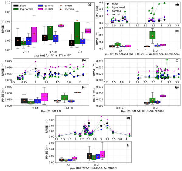
Understanding snow depth on sea ice is key for measuring ice thickness, studying ecosystems, and modelling climate. Using snow and ice thickness measurements from Arctic and Antarctic campaigns, this study examines sub-kilometre-scale (<1 km²) snow depth variations and identifies the most suitable statistical models for different ice ages, thicknesses, and weather conditions. These results can improve sub-grid snow parameterisations in snow models and remote sensing algorithms.
Achref Othmani, Annette Samuelsen, Jiping Xie, Laurent Bertino, Fabio Mangini, and Roshin Pappukutty Raj
EGUsphere, https://doi.org/10.5194/egusphere-2026-1520, https://doi.org/10.5194/egusphere-2026-1520, 2026
Short summary
Short summary
We developed a high-resolution (6–10 km) HYCOM-CICE configuration to better understand ocean and sea ice conditions in the Arctic and North Atlantic from 2009 to 2019. By comparing the model with available datasets, we found it reliably captures major patterns and seasonal changes. This can support forecasting, helping improve environmental monitoring and decision-making in regions sensitive to climate change.
Solène Jousset, Sandrine Mulet, Eric Greiner, John Wilkin, Lien Vidar, Léon Chafik, Roshin Raj, Antonio Bonaduce, Nicolas Picot, and Gérald Dibarboure
Earth Syst. Sci. Data, 18, 2285–2303, https://doi.org/10.5194/essd-18-2285-2026, https://doi.org/10.5194/essd-18-2285-2026, 2026
Short summary
Short summary
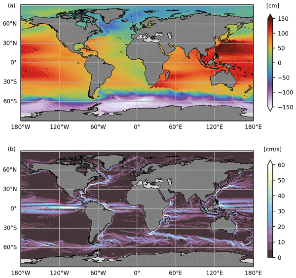
Satellite altimetry has revolutionized ocean observation, making it possible to track sea level with very good spatio-temporal coverage. However, only sea level anomalies are retrieved; to monitor the entire ocean signal, mean dynamic topography (MDT) must be added to these anomalies. In this study, an evaluation of the CNES-CLS22 MDT shows significant improvements in the Arctic. Over the globe, this new solution represents an incremental update to previous CNES-CLS18 MDT.
Rasmus Tage Tonboe, Vishnu Nandan, Marcus Huntemann, Julienne Stroeve, Randall Scharien, John Yackel, Lars Kaleschke, Hoyeon Shi, and Tânia Casal
EGUsphere, https://doi.org/10.5194/egusphere-2026-1440, https://doi.org/10.5194/egusphere-2026-1440, 2026
Short summary
Short summary
Scattering and absorption from air bubbles, voids, and brine pockets significantly affect radar and microwave radiometer measurements of sea ice and light propagation through sea ice. Here, we used a high-resolution dataset, collected during the 2019–20 MOSAiC expedition, of thin ice slices of various Arctic sea ice types to estimate the autocorrelation length and density of the inclusions. The data can be used to initialize sea ice scattering models and for understanding satellite data.
Nicole A. Loeb, Alex Crawford, Brice Noël, and Julienne Stroeve
The Cryosphere, 19, 5403–5422, https://doi.org/10.5194/tc-19-5403-2025, https://doi.org/10.5194/tc-19-5403-2025, 2025
Short summary
Short summary
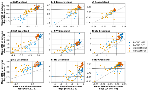
We examine how extreme precipitation days affect the seasonal mass balance (SMB) of land ice in Greenland and the Eastern Canadian Arctic in historical and future simulations. Past extreme precipitation led to higher SMB with snowfall. Future extreme precipitation may lead to the loss of ice mass as more falls as rain rather than snow in some regions, such as southwestern Greenland. Across the region, extreme precipitation becomes more important to seasonal SMB in the future, warmer climate.
Vaishali Chaudhary, Julienne Stroeve, Vishnu Nandan, and Dustin Isleifson
EGUsphere, https://doi.org/10.5194/egusphere-2025-2851, https://doi.org/10.5194/egusphere-2025-2851, 2025
Preprint archived
Short summary
Short summary
This study examines how changing weather is affecting sea ice near the Arctic community of Tuktoyaktuk in Canada. Using satellite images and weather records, we found that stronger winds from certain directions are causing the sea ice to break more often in winter. These changes pose risks for local people who depend on stable ice for travel and hunting. Our findings help understand how climate change is making Arctic ice less reliable and more dangerous.
Monojit Saha, Julienne Stroeve, Dustin Isleifson, John Yackel, Vishnu Nandan, Jack Christopher Landy, and Hoi Ming Lam
The Cryosphere, 19, 325–346, https://doi.org/10.5194/tc-19-325-2025, https://doi.org/10.5194/tc-19-325-2025, 2025
Short summary
Short summary
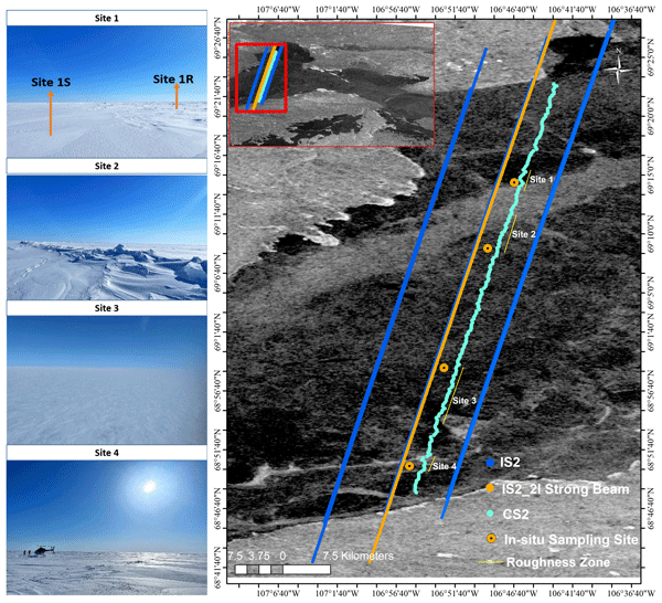
Snow on sea ice is vital for near-shore sea ice geophysical and biological processes. Past studies have measured snow depths using the satellite altimeters Cryosat-2 and ICESat-2 (Cryo2Ice), but estimating sea surface height from leadless landfast sea ice remains challenging. Snow depths from Cryo2Ice are compared to in situ data after adjusting for tides. Realistic snow depths are retrieved, but differences in roughness, satellite footprints, and snow geophysical properties are identified.
Caroline R. Holmes, Thomas J. Bracegirdle, Paul R. Holland, Julienne Stroeve, and Jeremy Wilkinson
The Cryosphere, 18, 5641–5652, https://doi.org/10.5194/tc-18-5641-2024, https://doi.org/10.5194/tc-18-5641-2024, 2024
Short summary
Short summary
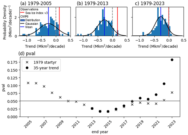
Until recently, satellite data showed an increase in Antarctic sea ice area since 1979, but climate models simulated a decrease over this period. This mismatch was one reason for low confidence in model projections of 21st-century sea ice loss. We show that following low Antarctic sea ice in 2022 and 2023, we can no longer conclude that modelled and observed trends differ. However, differences in the manner of the decline mean that model sea ice projections should still be viewed with caution.
José A. Jiménez, Gundula Winter, Antonio Bonaduce, Michael Depuydt, Giulia Galluccio, Bart van den Hurk, H. E. Markus Meier, Nadia Pinardi, Lavinia G. Pomarico, and Natalia Vazquez Riveiros
State Planet, 3-slre1, 3, https://doi.org/10.5194/sp-3-slre1-3-2024, https://doi.org/10.5194/sp-3-slre1-3-2024, 2024
Short summary
Short summary
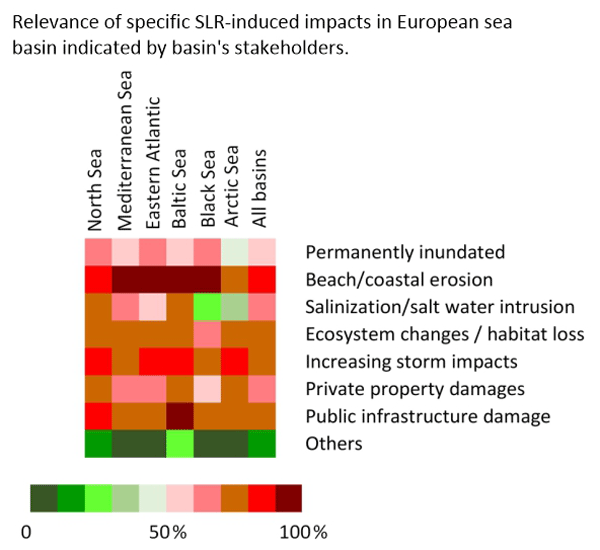
The Knowledge Hub on Sea Level Rise (SLR) has done a scoping study involving stakeholders from government and academia to identify gaps and needs in SLR information, impacts, and policies across Europe. Gaps in regional SLR projections and uncertainties were found, while concerns were raised about shoreline erosion and emerging problems like saltwater intrusion and ineffective adaptation plans. The need for improved communication to make better decisions on SLR adaptation was highlighted.
Karina von Schuckmann, Lorena Moreira, Mathilde Cancet, Flora Gues, Emmanuelle Autret, Ali Aydogdu, Lluis Castrillo, Daniele Ciani, Andrea Cipollone, Emanuela Clementi, Gianpiero Cossarini, Alvaro de Pascual-Collar, Vincenzo De Toma, Marion Gehlen, Rianne Giesen, Marie Drevillon, Claudia Fanelli, Kevin Hodges, Simon Jandt-Scheelke, Eric Jansen, Melanie Juza, Ioanna Karagali, Priidik Lagemaa, Vidar Lien, Leonardo Lima, Vladyslav Lyubartsev, Ilja Maljutenko, Simona Masina, Ronan McAdam, Pietro Miraglio, Helen Morrison, Tabea Rebekka Panteleit, Andrea Pisano, Marie-Isabelle Pujol, Urmas Raudsepp, Roshin Raj, Ad Stoffelen, Simon Van Gennip, Pierre Veillard, and Chunxue Yang
State Planet, 4-osr8, 2, https://doi.org/10.5194/sp-4-osr8-2-2024, https://doi.org/10.5194/sp-4-osr8-2-2024, 2024
Vidar S. Lien, Roshin P. Raj, and Sourav Chatterjee
State Planet, 4-osr8, 8, https://doi.org/10.5194/sp-4-osr8-8-2024, https://doi.org/10.5194/sp-4-osr8-8-2024, 2024
Short summary
Short summary
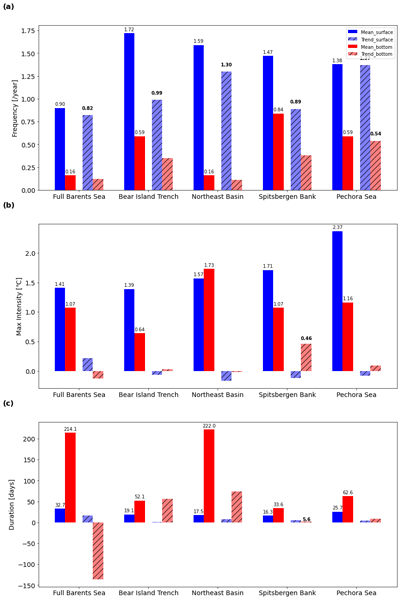
We find that major marine heatwaves are rather coherent throughout the Barents Sea, but surface marine heatwaves occur more frequently while heatwaves on the ocean floor have a longer duration. Moreover, we investigate the sensitivity to the choice of climatological average length when calculating marine heatwave statistics. Our results indicate that severe marine heatwaves may become more frequent in the future Barents Sea due to ongoing climate change.

Lu Zhou, Julienne Stroeve, Vishnu Nandan, Rosemary Willatt, Shiming Xu, Weixin Zhu, Sahra Kacimi, Stefanie Arndt, and Zifan Yang
The Cryosphere, 18, 4399–4434, https://doi.org/10.5194/tc-18-4399-2024, https://doi.org/10.5194/tc-18-4399-2024, 2024
Short summary
Short summary
Snow over Antarctic sea ice, influenced by highly variable meteorological conditions and heavy snowfall, has a complex stratigraphy and profound impact on the microwave signature. We employ advanced radiation transfer models to analyse the effects of complex snow properties on brightness temperatures over the sea ice in the Southern Ocean. Great potential lies in the understanding of snow processes and the application to satellite retrievals.
Rodric Mérimé Nonki, Ernest Amoussou, Raphael Muamba Tshimanga, Djan'na Koubodana Houteta, Domiho Japhet Kodja, Franck Eitel Kemgang Ghomsi, and André Lenouo
Proc. IAHS, 385, 319–326, https://doi.org/10.5194/piahs-385-319-2024, https://doi.org/10.5194/piahs-385-319-2024, 2024
Short summary
Short summary
This research aims to evaluate the feasibility of using multiple rainfall-runoff hydrologic models Génie Rural à 4, 5, 6 paramètres Journalier (GR4J, GR5J, and GR6J) in the Upper Benue River (UBR) in Northern Cameroon. By using the Michel's calibration algorithm, we found that the composite criterion is the most sustainable objective function for model optimization. An honest evaluation empirically proves that the GR6J model performs better than the other two models follow by GR5J.
Wiebke Margitta Kolbe, Rasmus T. Tonboe, and Julienne Stroeve
Earth Syst. Sci. Data, 16, 1247–1264, https://doi.org/10.5194/essd-16-1247-2024, https://doi.org/10.5194/essd-16-1247-2024, 2024
Short summary
Short summary
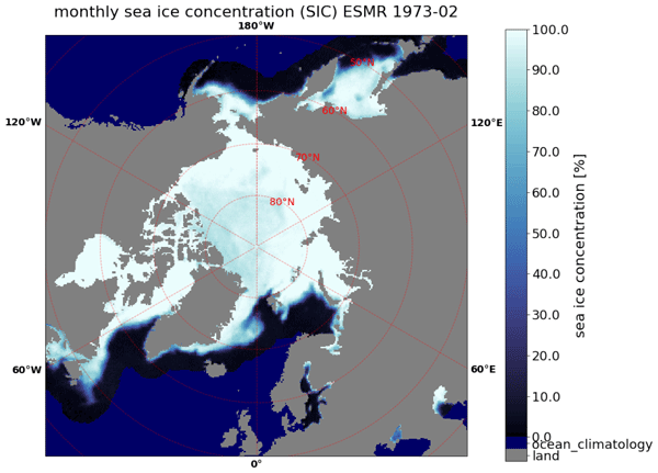
Current satellite-based sea-ice climate data records (CDRs) usually begin in October 1978 with the first multichannel microwave radiometer data. Here, we present a sea ice dataset based on the single-channel Electrical Scanning Microwave Radiometer (ESMR) that operated from 1972-1977 onboard NASA’s Nimbus 5 satellite. The data were processed using modern methods and include uncertainty estimations in order to provide an important, easy-to-use reference period of good quality for current CDRs.
Marta Umbert, Eva De Andrés, Maria Sánchez, Carolina Gabarró, Nina Hoareau, Veronica González-Gambau, Aina García-Espriu, Estrella Olmedo, Roshin P. Raj, Jiping Xie, and Rafael Catany
Ocean Sci., 20, 279–291, https://doi.org/10.5194/os-20-279-2024, https://doi.org/10.5194/os-20-279-2024, 2024
Short summary
Short summary
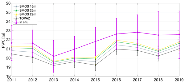
Satellite retrievals of sea surface salinity (SSS) offer insights into freshwater changes in the Arctic Ocean. This study evaluates freshwater content in the Beaufort Gyre using SMOS and reanalysis data, revealing underestimation with reanalysis alone. Incorporating satellite SSS measurements improves freshwater content estimation, especially near ice-melting areas. Adding remotely sensed salinity aids in monitoring Arctic freshwater content and in understanding its impact on global climate.
Alistair Duffey, Robbie Mallett, Peter J. Irvine, Michel Tsamados, and Julienne Stroeve
Earth Syst. Dynam., 14, 1165–1169, https://doi.org/10.5194/esd-14-1165-2023, https://doi.org/10.5194/esd-14-1165-2023, 2023
Short summary
Short summary
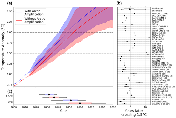
The Arctic is warming several times faster than the rest of the planet. Here, we use climate model projections to quantify for the first time how this faster warming in the Arctic impacts the timing of crossing the 1.5 °C and 2 °C thresholds defined in the Paris Agreement. We show that under plausible emissions scenarios that fail to meet the Paris 1.5 °C target, a hypothetical world without faster warming in the Arctic would breach that 1.5 °C target around 5 years later.

Vishnu Nandan, Rosemary Willatt, Robbie Mallett, Julienne Stroeve, Torsten Geldsetzer, Randall Scharien, Rasmus Tonboe, John Yackel, Jack Landy, David Clemens-Sewall, Arttu Jutila, David N. Wagner, Daniela Krampe, Marcus Huntemann, Mallik Mahmud, David Jensen, Thomas Newman, Stefan Hendricks, Gunnar Spreen, Amy Macfarlane, Martin Schneebeli, James Mead, Robert Ricker, Michael Gallagher, Claude Duguay, Ian Raphael, Chris Polashenski, Michel Tsamados, Ilkka Matero, and Mario Hoppmann
The Cryosphere, 17, 2211–2229, https://doi.org/10.5194/tc-17-2211-2023, https://doi.org/10.5194/tc-17-2211-2023, 2023
Short summary
Short summary
We show that wind redistributes snow on Arctic sea ice, and Ka- and Ku-band radar measurements detect both newly deposited snow and buried snow layers that can affect the accuracy of snow depth estimates on sea ice. Radar, laser, meteorological, and snow data were collected during the MOSAiC expedition. With frequent occurrence of storms in the Arctic, our results show that
wind-redistributed snow needs to be accounted for to improve snow depth estimates on sea ice from satellite radars.
Jiping Xie, Roshin P. Raj, Laurent Bertino, Justino Martínez, Carolina Gabarró, and Rafael Catany
Ocean Sci., 19, 269–287, https://doi.org/10.5194/os-19-269-2023, https://doi.org/10.5194/os-19-269-2023, 2023
Short summary
Short summary
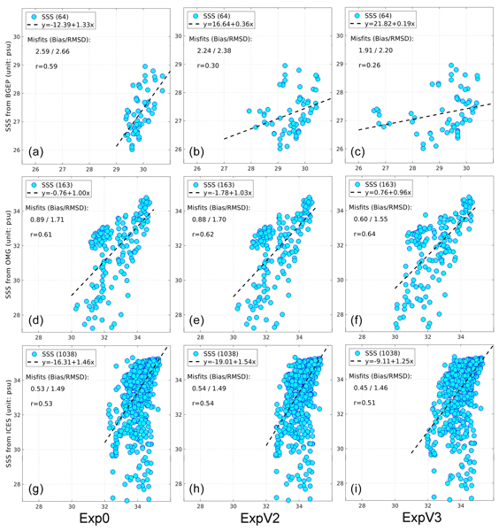
Sea ice melt, together with other freshwater sources, has effects on the Arctic environment. Sea surface salinity (SSS) plays a key role in representing water mixing. Recently the satellite SSS from SMOS was developed in the Arctic region. In this study, we first evaluate the impact of assimilating these satellite data in an Arctic reanalysis system. It shows that SSS errors are reduced by 10–50 % depending on areas, encouraging its use in a long-time reanalysis to monitor the Arctic water cycle.
Younjoo J. Lee, Wieslaw Maslowski, John J. Cassano, Jaclyn Clement Kinney, Anthony P. Craig, Samy Kamal, Robert Osinski, Mark W. Seefeldt, Julienne Stroeve, and Hailong Wang
The Cryosphere, 17, 233–253, https://doi.org/10.5194/tc-17-233-2023, https://doi.org/10.5194/tc-17-233-2023, 2023
Short summary
Short summary
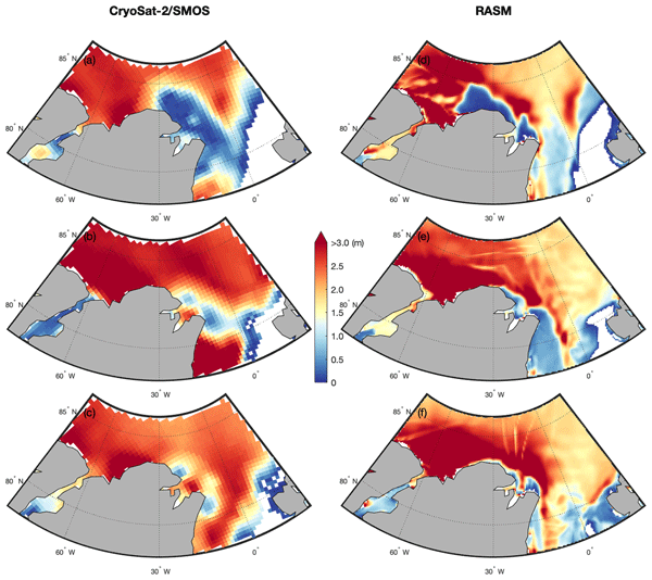
During 1979–2020, four winter polynyas occurred in December 1986 and February 2011, 2017, and 2018 north of Greenland. Instead of ice melting due to the anomalous warm air intrusion, the extreme wind forcing resulted in greater ice transport offshore. Based on the two ensemble runs, representing a 1980s thicker ice vs. a 2010s thinner ice, a dominant cause of these winter polynyas stems from internal variability of atmospheric forcing rather than from the forced response to a warming climate.
Julienne Stroeve, Vishnu Nandan, Rosemary Willatt, Ruzica Dadic, Philip Rostosky, Michael Gallagher, Robbie Mallett, Andrew Barrett, Stefan Hendricks, Rasmus Tonboe, Michelle McCrystall, Mark Serreze, Linda Thielke, Gunnar Spreen, Thomas Newman, John Yackel, Robert Ricker, Michel Tsamados, Amy Macfarlane, Henna-Reetta Hannula, and Martin Schneebeli
The Cryosphere, 16, 4223–4250, https://doi.org/10.5194/tc-16-4223-2022, https://doi.org/10.5194/tc-16-4223-2022, 2022
Short summary
Short summary
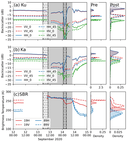
Impacts of rain on snow (ROS) on satellite-retrieved sea ice variables remain to be fully understood. This study evaluates the impacts of ROS over sea ice on active and passive microwave data collected during the 2019–20 MOSAiC expedition. Rainfall and subsequent refreezing of the snowpack significantly altered emitted and backscattered radar energy, laying important groundwork for understanding their impacts on operational satellite retrievals of various sea ice geophysical variables.
Vidar S. Lien and Roshin P. Raj
State Planet Discuss., https://doi.org/10.5194/sp-2022-13, https://doi.org/10.5194/sp-2022-13, 2022
Preprint withdrawn
Short summary
Short summary
Dense overflow water entering the North Atlantic from the Nordic Seas forms the northern limb of the Atlantic Meridional Overturning Circulation. The formation of dense water in the Nordic Seas is sensitive to the properties of the northward flowing Atlantic Water entering the Nordic Seas to the south. We find that the unprecedented freshwater anomaly in the North Atlantic recent years caused the dense water formed in the Barents Sea to have the lowest density in recorded history.
David N. Wagner, Matthew D. Shupe, Christopher Cox, Ola G. Persson, Taneil Uttal, Markus M. Frey, Amélie Kirchgaessner, Martin Schneebeli, Matthias Jaggi, Amy R. Macfarlane, Polona Itkin, Stefanie Arndt, Stefan Hendricks, Daniela Krampe, Marcel Nicolaus, Robert Ricker, Julia Regnery, Nikolai Kolabutin, Egor Shimanshuck, Marc Oggier, Ian Raphael, Julienne Stroeve, and Michael Lehning
The Cryosphere, 16, 2373–2402, https://doi.org/10.5194/tc-16-2373-2022, https://doi.org/10.5194/tc-16-2373-2022, 2022
Short summary
Short summary
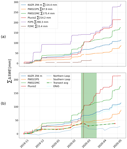
Based on measurements of the snow cover over sea ice and atmospheric measurements, we estimate snowfall and snow accumulation for the MOSAiC ice floe, between November 2019 and May 2020. For this period, we estimate 98–114 mm of precipitation. We suggest that about 34 mm of snow water equivalent accumulated until the end of April 2020 and that at least about 50 % of the precipitated snow was eroded or sublimated. Further, we suggest explanations for potential snowfall overestimation.
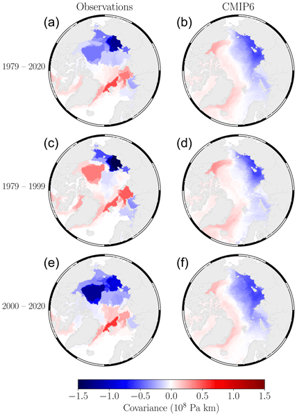
William Gregory, Julienne Stroeve, and Michel Tsamados
The Cryosphere, 16, 1653–1673, https://doi.org/10.5194/tc-16-1653-2022, https://doi.org/10.5194/tc-16-1653-2022, 2022
Short summary
Short summary
This research was conducted to better understand how coupled climate models simulate one of the large-scale interactions between the atmosphere and Arctic sea ice that we see in observational data, the accurate representation of which is important for producing reliable forecasts of Arctic sea ice on seasonal to inter-annual timescales. With network theory, this work shows that models do not reflect this interaction well on average, which is likely due to regional biases in sea ice thickness.
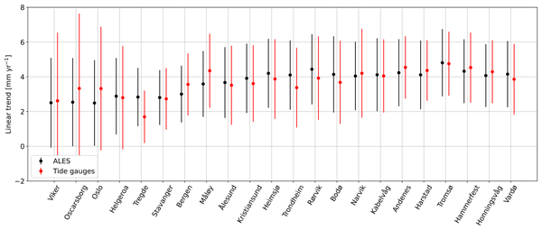
Fabio Mangini, Léon Chafik, Antonio Bonaduce, Laurent Bertino, and Jan Even Ø. Nilsen
Ocean Sci., 18, 331–359, https://doi.org/10.5194/os-18-331-2022, https://doi.org/10.5194/os-18-331-2022, 2022
Short summary
Short summary
We validate the recent ALES-reprocessed coastal satellite altimetry dataset along the Norwegian coast between 2003 and 2018. We find that coastal altimetry and conventional altimetry products perform similarly along the Norwegian coast. However, the agreement with tide gauges slightly increases in terms of trends when we use the ALES coastal altimetry data. We then use the ALES dataset and hydrographic stations to explore the steric contribution to the Norwegian sea-level anomaly.
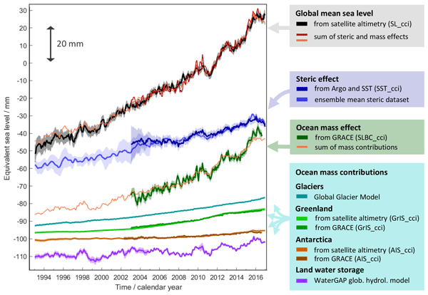
Martin Horwath, Benjamin D. Gutknecht, Anny Cazenave, Hindumathi Kulaiappan Palanisamy, Florence Marti, Ben Marzeion, Frank Paul, Raymond Le Bris, Anna E. Hogg, Inès Otosaka, Andrew Shepherd, Petra Döll, Denise Cáceres, Hannes Müller Schmied, Johnny A. Johannessen, Jan Even Øie Nilsen, Roshin P. Raj, René Forsberg, Louise Sandberg Sørensen, Valentina R. Barletta, Sebastian B. Simonsen, Per Knudsen, Ole Baltazar Andersen, Heidi Ranndal, Stine K. Rose, Christopher J. Merchant, Claire R. Macintosh, Karina von Schuckmann, Kristin Novotny, Andreas Groh, Marco Restano, and Jérôme Benveniste
Earth Syst. Sci. Data, 14, 411–447, https://doi.org/10.5194/essd-14-411-2022, https://doi.org/10.5194/essd-14-411-2022, 2022
Short summary
Short summary
Global mean sea-level change observed from 1993 to 2016 (mean rate of 3.05 mm yr−1) matches the combined effect of changes in water density (thermal expansion) and ocean mass. Ocean-mass change has been assessed through the contributions from glaciers, ice sheets, and land water storage or directly from satellite data since 2003. Our budget assessments of linear trends and monthly anomalies utilise new datasets and uncertainty characterisations developed within ESA's Climate Change Initiative.
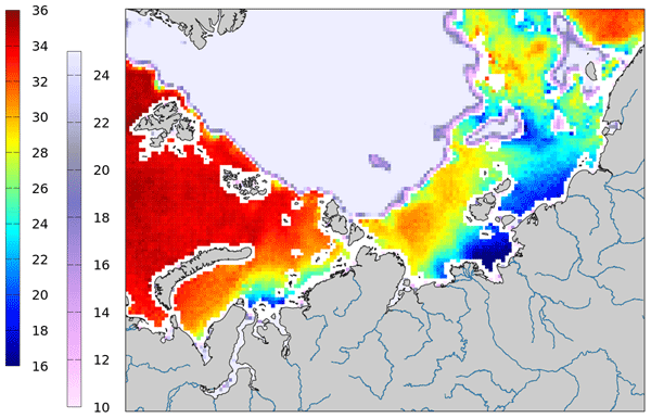
Justino Martínez, Carolina Gabarró, Antonio Turiel, Verónica González-Gambau, Marta Umbert, Nina Hoareau, Cristina González-Haro, Estrella Olmedo, Manuel Arias, Rafael Catany, Laurent Bertino, Roshin P. Raj, Jiping Xie, Roberto Sabia, and Diego Fernández
Earth Syst. Sci. Data, 14, 307–323, https://doi.org/10.5194/essd-14-307-2022, https://doi.org/10.5194/essd-14-307-2022, 2022
Short summary
Short summary
Measuring salinity from space is challenging since the sensitivity of the brightness temperature to sea surface salinity is low, but the retrieval of SSS in cold waters is even more challenging. In 2019, the ESA launched a specific initiative called Arctic+Salinity to produce an enhanced Arctic SSS product with better quality and resolution than the available products. This paper presents the methodologies used to produce the new enhanced Arctic SMOS SSS product.
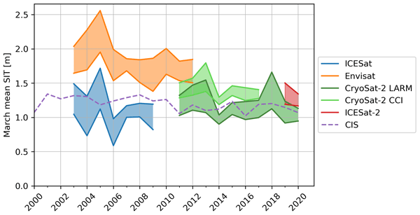
Isolde A. Glissenaar, Jack C. Landy, Alek A. Petty, Nathan T. Kurtz, and Julienne C. Stroeve
The Cryosphere, 15, 4909–4927, https://doi.org/10.5194/tc-15-4909-2021, https://doi.org/10.5194/tc-15-4909-2021, 2021
Short summary
Short summary
Scientists can estimate sea ice thickness using satellites that measure surface height. To determine the sea ice thickness, we also need to know the snow depth and density. This paper shows that the chosen snow depth product has a considerable impact on the findings of sea ice thickness state and trends in Baffin Bay, showing mean thinning with some snow depth products and mean thickening with others. This shows that it is important to better understand and monitor snow depth on sea ice.

The International Society for Photogrammetry and Remote Sensing is a non-governmental organization devoted to the development of international cooperation for the advancement of photogrammetry and remote sensing and their applications. The Society operates without any discrimination on grounds of race, religion, nationality, or political philosophy.
Useful Links
Useful External Links
Our Contact
c/o
Leibniz University Hannover
Institute of Photogrammetry and GeoInformation
Nienburger Str. 1
D-30167 Hannover
GERMANY
Email: isprs-sg@isprs.org