- Article
(19234 KB) - Metadata XML
- September 29, 2026
- |
- Home
- |
- Sitemap
- |
- The ISPRS Foundation
- |
- 𝕏
The International Archives of the Photogrammetry, Remote Sensing and Spatial Information Sciences





Articles | Volume XLIII-B2-2022
https://doi.org/10.5194/isprs-archives-XLIII-B2-2022-577-2022
© Author(s) 2022. This work is distributed under
the Creative Commons Attribution 4.0 License.
the Creative Commons Attribution 4.0 License.
https://doi.org/10.5194/isprs-archives-XLIII-B2-2022-577-2022
© Author(s) 2022. This work is distributed under
the Creative Commons Attribution 4.0 License.
the Creative Commons Attribution 4.0 License.

30 May 2022
| 30 May 2022
DEEP CONVOLUTION NEURAL NETWORKS WITH RESNET ARCHITECTURE FOR SPECTRAL-SPATIAL CLASSIFICATION OF DRONE BORNE AND GROUND BASED HIGH RESOLUTION HYPERSPECTRAL IMAGERY
A. Galodha
Department of Earth and Space Sciences, Indian Institute of Space Science and Technology (IIST), Department of Space, DoS, ISRO, Trivandrum, India
R. Vashisht
Department of Earth and Space Sciences, Indian Institute of Space Science and Technology (IIST), Department of Space, DoS, ISRO, Trivandrum, India
R. R. Nidamanuri
Department of Earth and Space Sciences, Indian Institute of Space Science and Technology (IIST), Department of Space, DoS, ISRO, Trivandrum, India
A. M. Ramiya
Department of Earth and Space Sciences, Indian Institute of Space Science and Technology (IIST), Department of Space, DoS, ISRO, Trivandrum, India
Related authors
Abhinav Galodha and Deepika Sharma
Int. Arch. Photogramm. Remote Sens. Spatial Inf. Sci., XLIX-B3-2026, 753–765, https://doi.org/10.5194/isprs-archives-XLIX-B3-2026-753-2026, https://doi.org/10.5194/isprs-archives-XLIX-B3-2026-753-2026, 2026
Abhinav Galodha, Deepika Sharma, and Jagdeep Verma
Int. Arch. Photogramm. Remote Sens. Spatial Inf. Sci., XLVIII-G-2025, 481–487, https://doi.org/10.5194/isprs-archives-XLVIII-G-2025-481-2025, https://doi.org/10.5194/isprs-archives-XLVIII-G-2025-481-2025, 2025
Abhinav Galodha, Faisal Hussain, Sanya Anees, Brejesh Lall, and Shaikh Ziauddin Ahammad
ISPRS Ann. Photogramm. Remote Sens. Spatial Inf. Sci., X-G-2025, 277–284, https://doi.org/10.5194/isprs-annals-X-G-2025-277-2025, https://doi.org/10.5194/isprs-annals-X-G-2025-277-2025, 2025
K. N. Sai, A. Galodha, P. Jain, and D. Sharma
Int. Arch. Photogramm. Remote Sens. Spatial Inf. Sci., XLVIII-1-W2-2023, 1265–1270, https://doi.org/10.5194/isprs-archives-XLVIII-1-W2-2023-1265-2023, https://doi.org/10.5194/isprs-archives-XLVIII-1-W2-2023-1265-2023, 2023
A. Galodha, N. S. Kayithi, D. Sharma, and P. Jain
Int. Arch. Photogramm. Remote Sens. Spatial Inf. Sci., XLVIII-M-3-2023, 95–100, https://doi.org/10.5194/isprs-archives-XLVIII-M-3-2023-95-2023, https://doi.org/10.5194/isprs-archives-XLVIII-M-3-2023-95-2023, 2023
A. Galodha, N. T. Ngoc, D. Raniwala, and S. Mundia
Int. Arch. Photogramm. Remote Sens. Spatial Inf. Sci., XLVI-M-2-2022, 233–239, https://doi.org/10.5194/isprs-archives-XLVI-M-2-2022-233-2022, https://doi.org/10.5194/isprs-archives-XLVI-M-2-2022-233-2022, 2022
A. Galodha and S. K. Gupta
Int. Arch. Photogramm. Remote Sens. Spatial Inf. Sci., XLIV-M-3-2021, 57–62, https://doi.org/10.5194/isprs-archives-XLIV-M-3-2021-57-2021, https://doi.org/10.5194/isprs-archives-XLIV-M-3-2021-57-2021, 2021
Abhinav Galodha and Deepika Sharma
Int. Arch. Photogramm. Remote Sens. Spatial Inf. Sci., XLIX-B3-2026, 753–765, https://doi.org/10.5194/isprs-archives-XLIX-B3-2026-753-2026, https://doi.org/10.5194/isprs-archives-XLIX-B3-2026-753-2026, 2026
Mohana Murugan and Anandakumar M. Ramiya
ISPRS Ann. Photogramm. Remote Sens. Spatial Inf. Sci., XI-3-2026, 223–229, https://doi.org/10.5194/isprs-annals-XI-3-2026-223-2026, https://doi.org/10.5194/isprs-annals-XI-3-2026-223-2026, 2026
Bhargav Parulekar and Anandakumar M. Ramiya
ISPRS Ann. Photogramm. Remote Sens. Spatial Inf. Sci., XI-3-2026, 231–236, https://doi.org/10.5194/isprs-annals-XI-3-2026-231-2026, https://doi.org/10.5194/isprs-annals-XI-3-2026-231-2026, 2026
Jayati Vijaywargiya and Anandakumar M. Ramiya
ISPRS Ann. Photogramm. Remote Sens. Spatial Inf. Sci., XI-3-2026, 297–305, https://doi.org/10.5194/isprs-annals-XI-3-2026-297-2026, https://doi.org/10.5194/isprs-annals-XI-3-2026-297-2026, 2026
Abhinav Galodha, Deepika Sharma, and Jagdeep Verma
Int. Arch. Photogramm. Remote Sens. Spatial Inf. Sci., XLVIII-G-2025, 481–487, https://doi.org/10.5194/isprs-archives-XLVIII-G-2025-481-2025, https://doi.org/10.5194/isprs-archives-XLVIII-G-2025-481-2025, 2025
Abhinav Galodha, Faisal Hussain, Sanya Anees, Brejesh Lall, and Shaikh Ziauddin Ahammad
ISPRS Ann. Photogramm. Remote Sens. Spatial Inf. Sci., X-G-2025, 277–284, https://doi.org/10.5194/isprs-annals-X-G-2025-277-2025, https://doi.org/10.5194/isprs-annals-X-G-2025-277-2025, 2025
Siddharth Singh Chauhan, T.V. Jayakumar, Deepak Mishra, and Anandakumar M. Ramiya
Int. Arch. Photogramm. Remote Sens. Spatial Inf. Sci., XLVIII-4-2024, 107–112, https://doi.org/10.5194/isprs-archives-XLVIII-4-2024-107-2024, https://doi.org/10.5194/isprs-archives-XLVIII-4-2024-107-2024, 2024
K. N. Sai, A. Galodha, P. Jain, and D. Sharma
Int. Arch. Photogramm. Remote Sens. Spatial Inf. Sci., XLVIII-1-W2-2023, 1265–1270, https://doi.org/10.5194/isprs-archives-XLVIII-1-W2-2023-1265-2023, https://doi.org/10.5194/isprs-archives-XLVIII-1-W2-2023-1265-2023, 2023
J. Vijaywargiya and A. M. Ramiya
ISPRS Ann. Photogramm. Remote Sens. Spatial Inf. Sci., X-1-W1-2023, 25–31, https://doi.org/10.5194/isprs-annals-X-1-W1-2023-25-2023, https://doi.org/10.5194/isprs-annals-X-1-W1-2023-25-2023, 2023
A. Galodha, N. S. Kayithi, D. Sharma, and P. Jain
Int. Arch. Photogramm. Remote Sens. Spatial Inf. Sci., XLVIII-M-3-2023, 95–100, https://doi.org/10.5194/isprs-archives-XLVIII-M-3-2023-95-2023, https://doi.org/10.5194/isprs-archives-XLVIII-M-3-2023-95-2023, 2023
Kumar Abhijeet, Thota Narayana Rao, Nidamanuri Rama Rao, and Kasimahanthi Amar Jyothi
Atmos. Meas. Tech., 16, 871–888, https://doi.org/10.5194/amt-16-871-2023, https://doi.org/10.5194/amt-16-871-2023, 2023
Short summary
Short summary
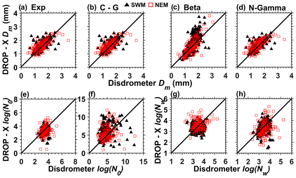
The present study focuses on retrieving and validating raindrop size distribution (DSD) relations for monsoonal rainfall, which are required for retrieving DSDs with polarimetric radar measurements. The seasonal variation in DSD is quite large and significant, and as a result the coefficients also vary considerably between the seasons and from those existing elsewhere. Among the existing DSD methods, the N-gamma method performs better than the other methods.
A. Galodha, N. T. Ngoc, D. Raniwala, and S. Mundia
Int. Arch. Photogramm. Remote Sens. Spatial Inf. Sci., XLVI-M-2-2022, 233–239, https://doi.org/10.5194/isprs-archives-XLVI-M-2-2022-233-2022, https://doi.org/10.5194/isprs-archives-XLVI-M-2-2022-233-2022, 2022
A. Galodha and S. K. Gupta
Int. Arch. Photogramm. Remote Sens. Spatial Inf. Sci., XLIV-M-3-2021, 57–62, https://doi.org/10.5194/isprs-archives-XLIV-M-3-2021-57-2021, https://doi.org/10.5194/isprs-archives-XLIV-M-3-2021-57-2021, 2021

The International Society for Photogrammetry and Remote Sensing is a non-governmental organization devoted to the development of international cooperation for the advancement of photogrammetry and remote sensing and their applications. The Society operates without any discrimination on grounds of race, religion, nationality, or political philosophy.
Useful Links
Useful External Links
Our Contact
c/o
Leibniz University Hannover
Institute of Photogrammetry and GeoInformation
Nienburger Str. 1
D-30167 Hannover
GERMANY
Email: isprs-sg@isprs.org