- Article
(2132 KB) - Metadata XML
- October 25, 2026
- |
- Home
- |
- Sitemap
- |
- The ISPRS Foundation
- |
- 𝕏
The International Archives of the Photogrammetry, Remote Sensing and Spatial Information Sciences





Articles | Volume XLVI-M-2-2022
https://doi.org/10.5194/isprs-archives-XLVI-M-2-2022-203-2022
© Author(s) 2022. This work is distributed under
the Creative Commons Attribution 4.0 License.
the Creative Commons Attribution 4.0 License.
https://doi.org/10.5194/isprs-archives-XLVI-M-2-2022-203-2022
© Author(s) 2022. This work is distributed under
the Creative Commons Attribution 4.0 License.
the Creative Commons Attribution 4.0 License.

25 Jul 2022
| 25 Jul 2022
AUTOMATED RECOGNITION OF PERMAFROST DISTURBANCES USING HIGH-SPATIAL RESOLUTION SATELLITE IMAGERY AND DEEP LEARNING MODELS
M. R. Udawalpola
Dept. of Natural Resources and the Environment, University of Connecticut, Storrs, Connecticut, USA
C. Witharana
Dept. of Natural Resources and the Environment, University of Connecticut, Storrs, Connecticut, USA
A. Hasan
Dept. of Natural Resources and the Environment, University of Connecticut, Storrs, Connecticut, USA
A. Liljedahl
Woodwell Climate Research Center, Falmouth, Massachusetts, USA
M. Ward Jones
University of Alaska Fairbanks, AK, USA
University of Alaska Fairbanks, AK, USA
Related authors
A. Hasan, C. Witharana, M. R. Udawalpola, and A. K. Liljedahl
Int. Arch. Photogramm. Remote Sens. Spatial Inf. Sci., XLVI-M-2-2022, 103–109, https://doi.org/10.5194/isprs-archives-XLVI-M-2-2022-103-2022, https://doi.org/10.5194/isprs-archives-XLVI-M-2-2022-103-2022, 2022
Galina Wind, Claire Porter, and Anna K. Liljedahl
EGUsphere, https://doi.org/10.5194/egusphere-2026-5750, https://doi.org/10.5194/egusphere-2026-5750, 2026
This preprint is open for discussion and under review for Atmospheric Measurement Techniques (AMT).
Short summary
Short summary
Commercial platforms like WorldView-3 present a unique source of data for many applications due to their sub-meter resolution. To make the data usable for land feature detections, automated cloud screening is needed. WorldView-3 currently reports a single cloudy percent number for the scene, often inaccurate. The method is proprietary. We show a new general-purpose cloud masking method for WorldView-3 that is free to use and develop further. We show a variety of results and initial validation.
Barbara Widhalm, Annett Bartsch, and Benjamin Jones
The Cryosphere, 20, 4619–4654, https://doi.org/10.5194/tc-20-4619-2026, https://doi.org/10.5194/tc-20-4619-2026, 2026
Short summary
Short summary
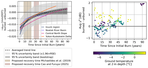
This study examines the impacts of wildfires on permafrost thaw in the Arctic spanning up to ~90 years post-fire and explores the potential of using radar satellite observations to enhance our understanding of environmental change. By assessing diverse high-latitude permafrost landscapes, we show that ground deformation anomalies after fires display similar patterns across regions, while radar backscatter varies depending on predominant ground temperatures.
Jaya Sree Mugunthan, Claude R. Duguay, Justin Murfitt, Elena Zakharova, and Benjamin M. Jones
EGUsphere, https://doi.org/10.5194/egusphere-2026-4309, https://doi.org/10.5194/egusphere-2026-4309, 2026
This preprint is open for discussion and under review for The Cryosphere (TC).
Short summary
Short summary
This paper explores how the new Surface Water and Ocean Topography (SWOT) satellite can improve monitoring of lake ice and seasonal changes in cold regions. Although SWOT observes water surfaces worldwide, how its measurements respond to frozen lakes is not yet well understood. We show that these observations can reveal important ice features, freeze–melt transitions, and changes in snow and ice conditions. The results provide new opportunities for monitoring frozen freshwater environments.
Fabian Seemann, Michael Zech, Maren Jenrich, Guido Grosse, Benjamin M. Jones, Claire Treat, Lutz Schirrmeister, Susanne Liebner, and Jens Strauss
Biogeosciences, 23, 3675–3695, https://doi.org/10.5194/bg-23-3675-2026, https://doi.org/10.5194/bg-23-3675-2026, 2026
Short summary
Short summary
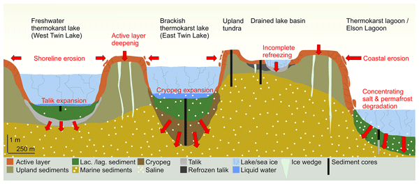
Arctic coastal landscapes, like those in northernmost Alaska, are often characterized by saline permafrost which is prone to thawing. We studied six sediment cores to understand how thawing and salinity affect organic matter breakdown and landscape change. Our results show that salinity accelerates organic matter degradation when permafrost thaws. This highlights the overlooked risk of salinity in shaping Arctic landscapes and carbon mineralization as the climate continues to warm.
Frieda P. Giest, Maren Jenrich, Guido Grosse, Benjamin M. Jones, Kai Mangelsdorf, Torben Windirsch, and Jens Strauss
Biogeosciences, 22, 2871–2887, https://doi.org/10.5194/bg-22-2871-2025, https://doi.org/10.5194/bg-22-2871-2025, 2025
Short summary
Short summary
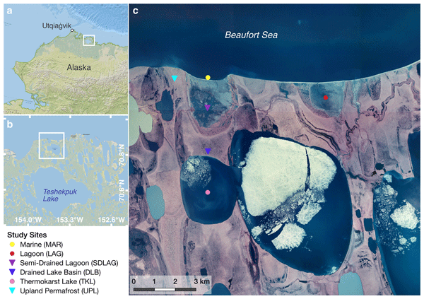
Climate warming causes permafrost to thaw, releasing greenhouse gases and affecting ecosystems. We studied sediments from Arctic coastal landscapes, including land, lakes, lagoons, and the ocean, finding that organic carbon storage and quality vary with landscape features and saltwater influence. Freshwater and land areas store more carbon, while saltwater reduces its quality. These findings improve predictions of Arctic responses to climate change and their impact on global carbon cycling.
Noriaki Ohara, Andrew D. Parsekian, Benjamin M. Jones, Rodrigo C. Rangel, Kenneth M. Hinkel, and Rui A. P. Perdigão
The Cryosphere, 18, 5139–5152, https://doi.org/10.5194/tc-18-5139-2024, https://doi.org/10.5194/tc-18-5139-2024, 2024
Short summary
Short summary
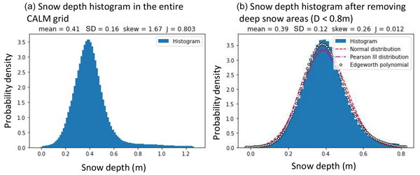
Snow distribution characterization is essential for accurate snow water estimation for water resource prediction from existing in situ observations and remote-sensing data at a finite spatial resolution. Four different observed snow distribution datasets were analyzed for Gaussianity. We found that non-Gaussianity of snow distribution is a signature of the wind redistribution effect. Generally, seasonal snowpack can be approximated well by a Gaussian distribution for a fully snow-covered area.
Lydia Stolpmann, Ingmar Nitze, Ingeborg Bussmann, Benjamin M. Jones, Josefine Lenz, Hanno Meyer, Juliane Wolter, and Guido Grosse
EGUsphere, https://doi.org/10.5194/egusphere-2024-2822, https://doi.org/10.5194/egusphere-2024-2822, 2024
Preprint archived
Short summary
Short summary
We combine hydrochemical and lake change data to show consequences of permafrost thaw induced lake changes on hydrochemistry, which are relevant for the global carbon cycle. We found higher methane concentrations in lakes that do not freeze to the ground and show that lagoons have lower methane concentrations than lakes. Our detailed lake sampling approach show higher concentrations in Dissolved Organic Carbon in areas of higher erosion rates, that might increase under the climate warming.
Mauricio Arboleda-Zapata, Michael Angelopoulos, Pier Paul Overduin, Guido Grosse, Benjamin M. Jones, and Jens Tronicke
The Cryosphere, 16, 4423–4445, https://doi.org/10.5194/tc-16-4423-2022, https://doi.org/10.5194/tc-16-4423-2022, 2022
Short summary
Short summary
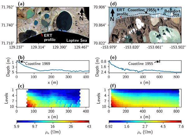
We demonstrate how we can reliably estimate the thawed–frozen permafrost interface with its associated uncertainties in subsea permafrost environments using 2D electrical resistivity tomography (ERT) data. In addition, we show how further analyses considering 1D inversion and sensitivity assessments can help quantify and better understand 2D ERT inversion results. Our results illustrate the capabilities of the ERT method to get insights into the development of the subsea permafrost.
Jason A. Clark, Elchin E. Jafarov, Ken D. Tape, Benjamin M. Jones, and Victor Stepanenko
Geosci. Model Dev., 15, 7421–7448, https://doi.org/10.5194/gmd-15-7421-2022, https://doi.org/10.5194/gmd-15-7421-2022, 2022
Short summary
Short summary
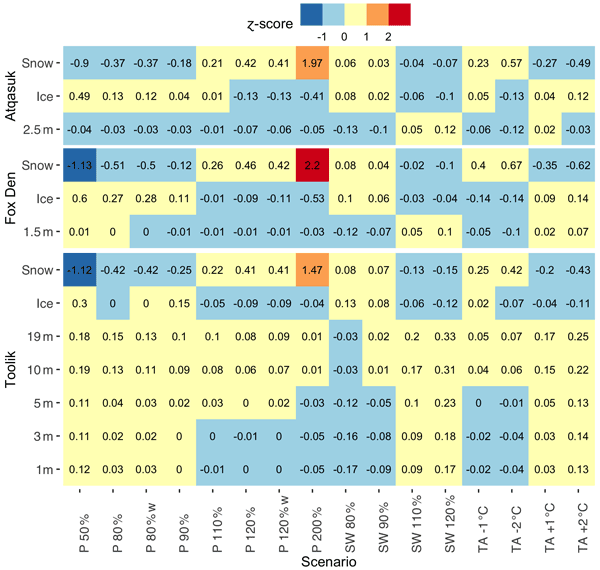
Lakes in the Arctic are important reservoirs of heat. Under climate warming scenarios, we expect Arctic lakes to warm the surrounding frozen ground. We simulate water temperatures in three Arctic lakes in northern Alaska over several years. Our results show that snow depth and lake ice strongly affect water temperatures during the frozen season and that more heat storage by lakes would enhance thawing of frozen ground.
A. Hasan, C. Witharana, M. R. Udawalpola, and A. K. Liljedahl
Int. Arch. Photogramm. Remote Sens. Spatial Inf. Sci., XLVI-M-2-2022, 103–109, https://doi.org/10.5194/isprs-archives-XLVI-M-2-2022-103-2022, https://doi.org/10.5194/isprs-archives-XLVI-M-2-2022-103-2022, 2022
D. Joshi and C. Witharana
Int. Arch. Photogramm. Remote Sens. Spatial Inf. Sci., XLVI-M-2-2022, 135–140, https://doi.org/10.5194/isprs-archives-XLVI-M-2-2022-135-2022, https://doi.org/10.5194/isprs-archives-XLVI-M-2-2022-135-2022, 2022
H. Wedegedara, C. Witharana, D. Joshi, D. Cerrai, and R. Fahey
Int. Arch. Photogramm. Remote Sens. Spatial Inf. Sci., XLVI-M-2-2022, 217–224, https://doi.org/10.5194/isprs-archives-XLVI-M-2-2022-217-2022, https://doi.org/10.5194/isprs-archives-XLVI-M-2-2022-217-2022, 2022
Noriaki Ohara, Benjamin M. Jones, Andrew D. Parsekian, Kenneth M. Hinkel, Katsu Yamatani, Mikhail Kanevskiy, Rodrigo C. Rangel, Amy L. Breen, and Helena Bergstedt
The Cryosphere, 16, 1247–1264, https://doi.org/10.5194/tc-16-1247-2022, https://doi.org/10.5194/tc-16-1247-2022, 2022
Short summary
Short summary
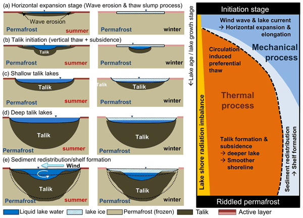
New variational principle suggests that a semi-ellipsoid talik shape (3D Stefan equation) is optimum for incoming energy. However, the lake bathymetry tends to be less ellipsoidal due to the ice-rich layers near the surface. Wind wave erosion is likely responsible for the elongation of lakes, while thaw subsidence slows the wave effect and stabilizes the thermokarst lakes. The derived 3D Stefan equation was compared to the field-observed talik thickness data using geophysical methods.

The International Society for Photogrammetry and Remote Sensing is a non-governmental organization devoted to the development of international cooperation for the advancement of photogrammetry and remote sensing and their applications. The Society operates without any discrimination on grounds of race, religion, nationality, or political philosophy.
Useful Links
Useful External Links
Our Contact
c/o
Leibniz University Hannover
Institute of Photogrammetry and GeoInformation
Nienburger Str. 1
D-30167 Hannover
GERMANY
Email: isprs-sg@isprs.org