- Article
(1358 KB) - Metadata XML
- October 26, 2026
- |
- Home
- |
- Sitemap
- |
- The ISPRS Foundation
- |
- 𝕏
The International Archives of the Photogrammetry, Remote Sensing and Spatial Information Sciences





Articles | Volume XLVIII-1/W2-2023
https://doi.org/10.5194/isprs-archives-XLVIII-1-W2-2023-989-2023
© Author(s) 2023. This work is distributed under
the Creative Commons Attribution 4.0 License.
the Creative Commons Attribution 4.0 License.
https://doi.org/10.5194/isprs-archives-XLVIII-1-W2-2023-989-2023
© Author(s) 2023. This work is distributed under
the Creative Commons Attribution 4.0 License.
the Creative Commons Attribution 4.0 License.

13 Dec 2023
| 13 Dec 2023
E-TRAINEE: OPEN E-LEARNING COURSE ON TIME SERIES ANALYSIS IN REMOTE SENSING
M. Potůčková
Charles University, Faculty of Science, Czech Republic
J. Albrechtová
Charles University, Faculty of Science, Czech Republic
K. Anders
Heidelberg University, Institute of Geography, 3DGeo Research Group, Germany
L. Červená
Charles University, Faculty of Science, Czech Republic
J. Dvořák
Charles University, Faculty of Science, Czech Republic
K. Gryguc
University of Warsaw, Chair of Geomatics and Information Systems, Department of Geoinformatics, Cartography and Remote Sensing, Poland
Heidelberg University, Institute of Geography, 3DGeo Research Group, Germany
L. Hunt
Charles University, Faculty of Science, Czech Republic
Z. Lhotáková
Charles University, Faculty of Science, Czech Republic
A. Marcinkowska-Ochtyra
University of Warsaw, Chair of Geomatics and Information Systems, Department of Geoinformatics, Cartography and Remote Sensing, Poland
A. Mayr
University of Innsbruck, Department of Geography, Remote Sensing & Topographic LiDAR Research Group, Austria
E. Neuwirthová
Charles University, Faculty of Science, Czech Republic
A. Ochtyra
University of Warsaw, Chair of Geomatics and Information Systems, Department of Geoinformatics, Cartography and Remote Sensing, Poland
M. Rutzinger
University of Innsbruck, Department of Geography, Remote Sensing & Topographic LiDAR Research Group, Austria
A. Šedová
Charles University, Faculty of Science, Czech Republic
A. Šrollerů
Charles University, Faculty of Science, Czech Republic
L. Kupková
Charles University, Faculty of Science, Czech Republic
Related authors
Anka Lisec, Markéta Potůčková, Joep Crompvoets, and Conor Cahalane
Int. Arch. Photogramm. Remote Sens. Spatial Inf. Sci., XLIX-B5-2026, 25–31, https://doi.org/10.5194/isprs-archives-XLIX-B5-2026-25-2026, https://doi.org/10.5194/isprs-archives-XLIX-B5-2026-25-2026, 2026
Alex Šrollerů, Jindřich Horák, Petr Dušánek, and Markéta Potůčková
ISPRS Ann. Photogramm. Remote Sens. Spatial Inf. Sci., XI-4-2026, 359–367, https://doi.org/10.5194/isprs-annals-XI-4-2026-359-2026, https://doi.org/10.5194/isprs-annals-XI-4-2026-359-2026, 2026
Lucie Kupková, Lucie Červená, Jakub Lysák, Záboj Hrázský, Markéta Potůčková, Alex Šrollerů, Barbora Novotná, Michaela Vítková, Jan Pergl, Jan Čuda, Natálie Kolombová, Klára Kušková, Josef Kutlvašr, Irena Perglová, Jiří Sádlo, Vojtěch Vítek, and Petr Pyšek
Int. Arch. Photogramm. Remote Sens. Spatial Inf. Sci., XLVIII-G-2025, 821–829, https://doi.org/10.5194/isprs-archives-XLVIII-G-2025-821-2025, https://doi.org/10.5194/isprs-archives-XLVIII-G-2025-821-2025, 2025
S. Bijou, L. Kupková, M. Potůčková, L. Červená, and J. Lysák
ISPRS Ann. Photogramm. Remote Sens. Spatial Inf. Sci., X-1-W1-2023, 1033–1040, https://doi.org/10.5194/isprs-annals-X-1-W1-2023-1033-2023, https://doi.org/10.5194/isprs-annals-X-1-W1-2023-1033-2023, 2023
V. Zahs, L. Winiwarter, K. Anders, M. Bremer, M. Rutzinger, M. Potůčková, and B. Höfle
Int. Arch. Photogramm. Remote Sens. Spatial Inf. Sci., XLIII-B2-2022, 1109–1116, https://doi.org/10.5194/isprs-archives-XLIII-B2-2022-1109-2022, https://doi.org/10.5194/isprs-archives-XLIII-B2-2022-1109-2022, 2022
L. Červená, G. Pinlová, Z. Lhotáková, E. Neuwirthová, L. Kupková, M. Potůčková, J. Lysák, P. Campbell, and J. Albrechtová
Int. Arch. Photogramm. Remote Sens. Spatial Inf. Sci., XLIII-B3-2022, 381–388, https://doi.org/10.5194/isprs-archives-XLIII-B3-2022-381-2022, https://doi.org/10.5194/isprs-archives-XLIII-B3-2022-381-2022, 2022
J. Dvořák, M. Potůčková, and V. Treml
ISPRS Ann. Photogramm. Remote Sens. Spatial Inf. Sci., V-3-2022, 33–38, https://doi.org/10.5194/isprs-annals-V-3-2022-33-2022, https://doi.org/10.5194/isprs-annals-V-3-2022-33-2022, 2022
Anka Lisec, Markéta Potůčková, Joep Crompvoets, and Conor Cahalane
Int. Arch. Photogramm. Remote Sens. Spatial Inf. Sci., XLIX-B5-2026, 25–31, https://doi.org/10.5194/isprs-archives-XLIX-B5-2026-25-2026, https://doi.org/10.5194/isprs-archives-XLIX-B5-2026-25-2026, 2026
Geng Wang, Aurora Bozzini, Luiz Henrique Elias Cosimo, Emma Turkulainen, Salma Bijou, Raquel Alves de Oliveira, Juha Suomalainen, Erika Vennervirta, Niko Koivumäki, Roope Näsi, Lucie Kupková, Massimo Faccoli, Eija Honkavaara, and Langning Huo
Int. Arch. Photogramm. Remote Sens. Spatial Inf. Sci., XLIX-B3-2026, 1163–1170, https://doi.org/10.5194/isprs-archives-XLIX-B3-2026-1163-2026, https://doi.org/10.5194/isprs-archives-XLIX-B3-2026-1163-2026, 2026
Alex Šrollerů, Jindřich Horák, Petr Dušánek, and Markéta Potůčková
ISPRS Ann. Photogramm. Remote Sens. Spatial Inf. Sci., XI-4-2026, 359–367, https://doi.org/10.5194/isprs-annals-XI-4-2026-359-2026, https://doi.org/10.5194/isprs-annals-XI-4-2026-359-2026, 2026
Sebastian Spreitzer, Georg Wohlfahrt, and Martin Rutzinger
ISPRS Ann. Photogramm. Remote Sens. Spatial Inf. Sci., XI-3-2026, 805–812, https://doi.org/10.5194/isprs-annals-XI-3-2026-805-2026, https://doi.org/10.5194/isprs-annals-XI-3-2026-805-2026, 2026
Benedikt Hiebl, Nicola Alessi, Giacomo Calvia, Alessandro Bricca, Gianmaria Bonari, Giulio Zangari, Stefan Zerbe, and Martin Rutzinger
ISPRS Ann. Photogramm. Remote Sens. Spatial Inf. Sci., XI-3-2026, 117–124, https://doi.org/10.5194/isprs-annals-XI-3-2026-117-2026, https://doi.org/10.5194/isprs-annals-XI-3-2026-117-2026, 2026
Xiaoyu Huang, Mathilde Letard, Dimitri Lague, Bernhard Höfle, Ronald Tabernig, Paul Leroy, and Katharina Anders
ISPRS Ann. Photogramm. Remote Sens. Spatial Inf. Sci., XI-2-2026, 623–630, https://doi.org/10.5194/isprs-annals-XI-2-2026-623-2026, https://doi.org/10.5194/isprs-annals-XI-2-2026-623-2026, 2026
Ronald Tabernig and Bernhard Höfle
ISPRS Ann. Photogramm. Remote Sens. Spatial Inf. Sci., XI-2-2026, 155–162, https://doi.org/10.5194/isprs-annals-XI-2-2026-155-2026, https://doi.org/10.5194/isprs-annals-XI-2-2026-155-2026, 2026
Daan Hulskemper, Hannah Weiser, Ronald Tabernig, Bernhard Höfle, Thomas de Jong, and Roderik Lindenbergh
ISPRS Ann. Photogramm. Remote Sens. Spatial Inf. Sci., XI-1-2026, 91–99, https://doi.org/10.5194/isprs-annals-XI-1-2026-91-2026, https://doi.org/10.5194/isprs-annals-XI-1-2026-91-2026, 2026
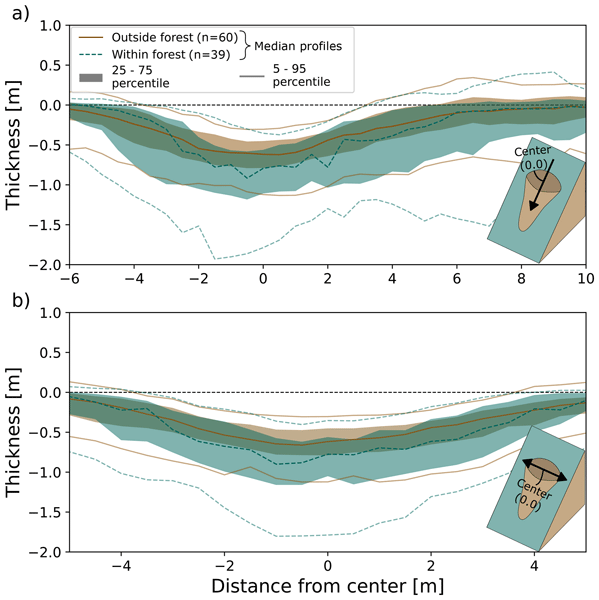
Lotte de Vugt, Thomas Zieher, Barbara Schneider-Muntau, Frank Perzl, Marc Adams, and Martin Rutzinger
Nat. Hazards Earth Syst. Sci., 26, 1375–1396, https://doi.org/10.5194/nhess-26-1375-2026, https://doi.org/10.5194/nhess-26-1375-2026, 2026
Short summary
Short summary
We performed an analysis on semi-automatically mapped shallow landslide scarps and forest cover in the Sellrain valley, Tyrol (Austria), to investigate how the morphology and topographic profiles of landslides are affected by the forest. The results show that landslides located in dense forest cover occurred on steeper slopes and were deeper than others. The results also show that the use of forest stand density parameters, such as tree spacing, enhanced the found differences in the study area.
Lucie Kupková, Lucie Červená, Jakub Lysák, Záboj Hrázský, Markéta Potůčková, Alex Šrollerů, Barbora Novotná, Michaela Vítková, Jan Pergl, Jan Čuda, Natálie Kolombová, Klára Kušková, Josef Kutlvašr, Irena Perglová, Jiří Sádlo, Vojtěch Vítek, and Petr Pyšek
Int. Arch. Photogramm. Remote Sens. Spatial Inf. Sci., XLVIII-G-2025, 821–829, https://doi.org/10.5194/isprs-archives-XLVIII-G-2025-821-2025, https://doi.org/10.5194/isprs-archives-XLVIII-G-2025-821-2025, 2025
Salma Bijou, Lucie Kupková, Lucie Červená, and Jakub Lysák
Int. Arch. Photogramm. Remote Sens. Spatial Inf. Sci., XLVIII-G-2025, 205–212, https://doi.org/10.5194/isprs-archives-XLVIII-G-2025-205-2025, https://doi.org/10.5194/isprs-archives-XLVIII-G-2025-205-2025, 2025
Jiapan Wang, Rasoul Eskandari, ChengHan Lin, János Mészáros, Laura Obrecht, Evangeline Rowe, Jules Salzinger, Martin Rutzinger, and Andreas Mayr
ISPRS Ann. Photogramm. Remote Sens. Spatial Inf. Sci., X-G-2025, 937–944, https://doi.org/10.5194/isprs-annals-X-G-2025-937-2025, https://doi.org/10.5194/isprs-annals-X-G-2025-937-2025, 2025
Jannik S. Meyer, Ronald Tabernig, and Bernhard Höfle
ISPRS Ann. Photogramm. Remote Sens. Spatial Inf. Sci., X-G-2025, 583–590, https://doi.org/10.5194/isprs-annals-X-G-2025-583-2025, https://doi.org/10.5194/isprs-annals-X-G-2025-583-2025, 2025
William Albert, Hannah Weiser, Ronald Tabernig, and Bernhard Höfle
ISPRS Ann. Photogramm. Remote Sens. Spatial Inf. Sci., X-G-2025, 25–32, https://doi.org/10.5194/isprs-annals-X-G-2025-25-2025, https://doi.org/10.5194/isprs-annals-X-G-2025-25-2025, 2025
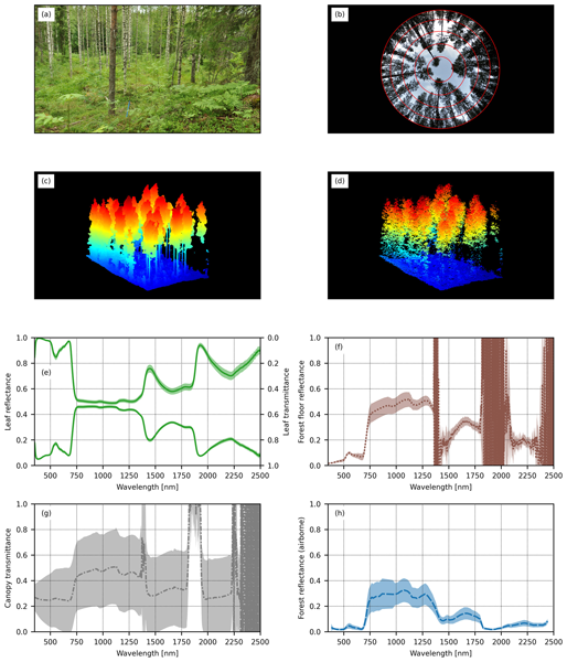
Miina Rautiainen, Aarne Hovi, Daniel Schraik, Jan Hanuš, Petr Lukeš, Zuzana Lhotáková, and Lucie Homolová
Earth Syst. Sci. Data, 16, 5069–5087, https://doi.org/10.5194/essd-16-5069-2024, https://doi.org/10.5194/essd-16-5069-2024, 2024
Short summary
Short summary
Radiative transfer models play a key role in monitoring vegetation using remote sensing data such as satellite or airborne images. The development of these models has been hindered by a lack of comprehensive ground reference data on structural and spectral characteristics of forests. Here, we reported datasets on the structural and spectral properties of temperate, hemiboreal, and boreal European forest stands. We anticipate that these data will have wide use in remote sensing applications.
S. Bijou, L. Kupková, M. Potůčková, L. Červená, and J. Lysák
ISPRS Ann. Photogramm. Remote Sens. Spatial Inf. Sci., X-1-W1-2023, 1033–1040, https://doi.org/10.5194/isprs-annals-X-1-W1-2023-1033-2023, https://doi.org/10.5194/isprs-annals-X-1-W1-2023-1033-2023, 2023
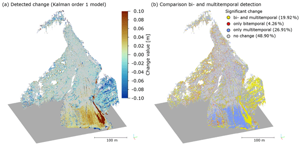
Lukas Winiwarter, Katharina Anders, Daniel Czerwonka-Schröder, and Bernhard Höfle
Earth Surf. Dynam., 11, 593–613, https://doi.org/10.5194/esurf-11-593-2023, https://doi.org/10.5194/esurf-11-593-2023, 2023
Short summary
Short summary
We present a method to extract surface change information from 4D time series of topographic point clouds recorded with a terrestrial laser scanner. The method uses sensor information to spatially and temporally smooth the data, reducing uncertainties. The Kalman filter used for the temporal smoothing also allows us to interpolate over data gaps or extrapolate into the future. Clustering areas where change histories are similar allows us to identify processes that may have the same causes.
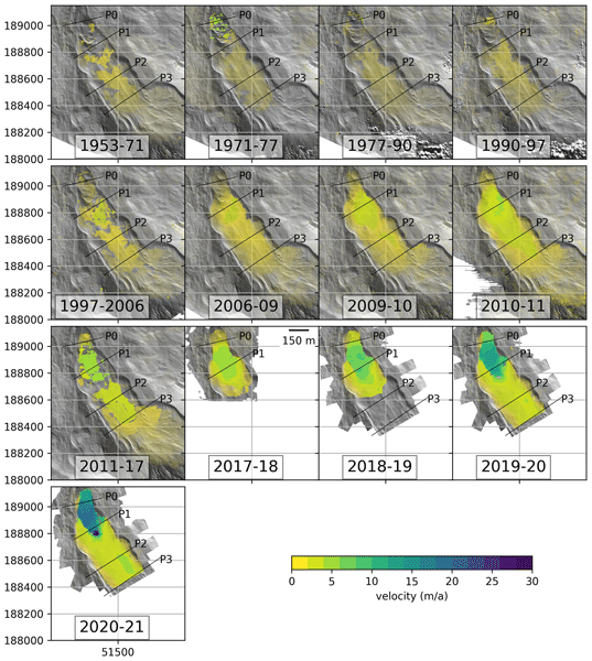
Lea Hartl, Thomas Zieher, Magnus Bremer, Martin Stocker-Waldhuber, Vivien Zahs, Bernhard Höfle, Christoph Klug, and Alessandro Cicoira
Earth Surf. Dynam., 11, 117–147, https://doi.org/10.5194/esurf-11-117-2023, https://doi.org/10.5194/esurf-11-117-2023, 2023
Short summary
Short summary
The rock glacier in Äußeres Hochebenkar (Austria) moved faster in 2021–2022 than it has in about 70 years of monitoring. It is currently destabilizing. Using a combination of different data types and methods, we show that there have been two cycles of destabilization at Hochebenkar and provide a detailed analysis of velocity and surface changes. Because our time series are very long and show repeated destabilization, this helps us better understand the processes of rock glacier destabilization.
D. Hulskemper, K. Anders, J. A. Á. Antolínez, M. Kuschnerus, B. Höfle, and R. Lindenbergh
Int. Arch. Photogramm. Remote Sens. Spatial Inf. Sci., XLVIII-2-W2-2022, 53–60, https://doi.org/10.5194/isprs-archives-XLVIII-2-W2-2022-53-2022, https://doi.org/10.5194/isprs-archives-XLVIII-2-W2-2022-53-2022, 2022

Jan Pfeiffer, Thomas Zieher, Jan Schmieder, Thom Bogaard, Martin Rutzinger, and Christoph Spötl
Nat. Hazards Earth Syst. Sci., 22, 2219–2237, https://doi.org/10.5194/nhess-22-2219-2022, https://doi.org/10.5194/nhess-22-2219-2022, 2022
Short summary
Short summary
The activity of slow-moving deep-seated landslides is commonly governed by pore pressure variations within the shear zone. Groundwater recharge as a consequence of precipitation therefore is a process regulating the activity of landslides. In this context, we present a highly automated geo-statistical approach to spatially assess groundwater recharge controlling the velocity of a deep-seated landslide in Tyrol, Austria.
Hannah Weiser, Jannika Schäfer, Lukas Winiwarter, Nina Krašovec, Fabian E. Fassnacht, and Bernhard Höfle
Earth Syst. Sci. Data, 14, 2989–3012, https://doi.org/10.5194/essd-14-2989-2022, https://doi.org/10.5194/essd-14-2989-2022, 2022
Short summary
Short summary
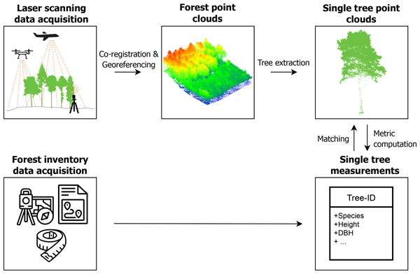
3D point clouds, acquired by laser scanning, allow us to retrieve information about forest structure and individual tree properties. We conducted airborne, UAV-borne and terrestrial laser scanning in German mixed forests, resulting in overlapping point clouds with different characteristics. From these, we generated a comprehensive database of individual tree point clouds and corresponding tree metrics. Our dataset may serve as a benchmark dataset for algorithms in forestry research.
L. Červená, G. Pinlová, Z. Lhotáková, E. Neuwirthová, L. Kupková, M. Potůčková, J. Lysák, P. Campbell, and J. Albrechtová
Int. Arch. Photogramm. Remote Sens. Spatial Inf. Sci., XLIII-B3-2022, 381–388, https://doi.org/10.5194/isprs-archives-XLIII-B3-2022-381-2022, https://doi.org/10.5194/isprs-archives-XLIII-B3-2022-381-2022, 2022
V. Zahs, L. Winiwarter, K. Anders, M. Bremer, M. Rutzinger, M. Potůčková, and B. Höfle
Int. Arch. Photogramm. Remote Sens. Spatial Inf. Sci., XLIII-B2-2022, 1109–1116, https://doi.org/10.5194/isprs-archives-XLIII-B2-2022-1109-2022, https://doi.org/10.5194/isprs-archives-XLIII-B2-2022-1109-2022, 2022
A. B. Voordendag, B. Goger, C. Klug, R. Prinz, M. Rutzinger, and G. Kaser
Int. Arch. Photogramm. Remote Sens. Spatial Inf. Sci., XLIII-B2-2022, 1093–1099, https://doi.org/10.5194/isprs-archives-XLIII-B2-2022-1093-2022, https://doi.org/10.5194/isprs-archives-XLIII-B2-2022-1093-2022, 2022
K. Anders, L. Winiwarter, D. Schröder, and B. Höfle
Int. Arch. Photogramm. Remote Sens. Spatial Inf. Sci., XLIII-B2-2022, 973–980, https://doi.org/10.5194/isprs-archives-XLIII-B2-2022-973-2022, https://doi.org/10.5194/isprs-archives-XLIII-B2-2022-973-2022, 2022
J. Dvořák, M. Potůčková, and V. Treml
ISPRS Ann. Photogramm. Remote Sens. Spatial Inf. Sci., V-3-2022, 33–38, https://doi.org/10.5194/isprs-annals-V-3-2022-33-2022, https://doi.org/10.5194/isprs-annals-V-3-2022-33-2022, 2022
L. Müller, M. Rutzinger, A. Mayr, and A. Kollert
ISPRS Ann. Photogramm. Remote Sens. Spatial Inf. Sci., V-2-2022, 391–398, https://doi.org/10.5194/isprs-annals-V-2-2022-391-2022, https://doi.org/10.5194/isprs-annals-V-2-2022-391-2022, 2022
B. Hiebl, A. Mayr, A. Kollert, M. Rutzinger, M. Bremer, N. Helm, and K. Chytry
ISPRS Ann. Photogramm. Remote Sens. Spatial Inf. Sci., V-2-2022, 367–374, https://doi.org/10.5194/isprs-annals-V-2-2022-367-2022, https://doi.org/10.5194/isprs-annals-V-2-2022-367-2022, 2022
L. Winiwarter, K. Anders, D. Schröder, and B. Höfle
ISPRS Ann. Photogramm. Remote Sens. Spatial Inf. Sci., V-2-2022, 79–86, https://doi.org/10.5194/isprs-annals-V-2-2022-79-2022, https://doi.org/10.5194/isprs-annals-V-2-2022-79-2022, 2022

The International Society for Photogrammetry and Remote Sensing is a non-governmental organization devoted to the development of international cooperation for the advancement of photogrammetry and remote sensing and their applications. The Society operates without any discrimination on grounds of race, religion, nationality, or political philosophy.
Useful Links
Useful External Links
Our Contact
c/o
Leibniz University Hannover
Institute of Photogrammetry and GeoInformation
Nienburger Str. 1
D-30167 Hannover
GERMANY
Email: isprs-sg@isprs.org